You are here: Home > Network List > TA - USArray Transportable Network (new EarthScope stations) Stations List
> Station HDA Harding Lake, AK, USA > Earthquake Result Viewer
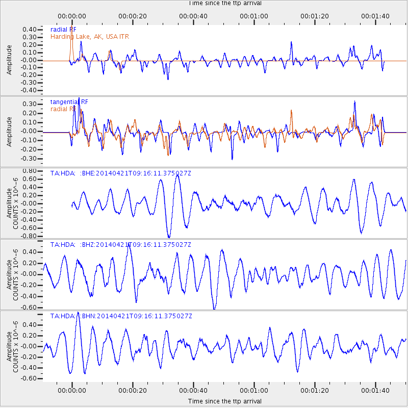
HDA Harding Lake, AK, USA - Earthquake Result Viewer
*The percent match for this event was below the threshold and hence no stack was calculated.
| Earthquake location: |
Solomon Islands |
| Earthquake latitude/longitude: |
-6.2/154.4 |
| Earthquake time(UTC): |
2014/04/21 (111) 09:04:24 GMT |
| Earthquake Depth: |
48 km |
| Earthquake Magnitude: |
5.6 MWW, 5.5 MWB, 5.6 MWC |
| Earthquake Catalog/Contributor: |
NEIC PDE/NEIC COMCAT |
|
| Network: |
TA USArray Transportable Network (new EarthScope stations) |
| Station: |
HDA Harding Lake, AK, USA |
| Lat/Lon: |
64.41 N/146.95 W |
| Elevation: |
437 m |
|
| Distance: |
82.7 deg |
| Az: |
21.957 deg |
| Baz: |
238.863 deg |
| Ray Param: |
$rayparam |
*The percent match for this event was below the threshold and hence was not used in the summary stack. |
|
| Radial Match: |
72.2793 % |
| Radial Bump: |
400 |
| Transverse Match: |
63.566822 % |
| Transverse Bump: |
346 |
| SOD ConfigId: |
626651 |
| Insert Time: |
2014-05-30 12:25:42.161 +0000 |
| GWidth: |
2.5 |
| Max Bumps: |
400 |
| Tol: |
0.001 |
|
Signal To Noise
| Channel | StoN | STA | LTA |
| TA:HDA: :BHZ:20140421T09:16:11.375027Z | 0.8939662 | 1.850767E-7 | 2.0702875E-7 |
| TA:HDA: :BHN:20140421T09:16:11.375027Z | 2.7157567 | 4.105923E-7 | 1.5118891E-7 |
| TA:HDA: :BHE:20140421T09:16:11.375027Z | 3.296217 | 5.4736574E-7 | 1.6605877E-7 |
| Arrivals |
| Ps | |
| PpPs | |
| PsPs/PpSs | |


