You are here: Home > Network List > UW - Pacific Northwest Regional Seismic Network Stations List
> Station UMAT Pilot Rock, OR, USA > Earthquake Result Viewer
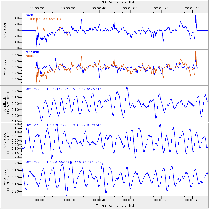
UMAT Pilot Rock, OR, USA - Earthquake Result Viewer
*The percent match for this event was below the threshold and hence no stack was calculated.
| Earthquake location: |
Tonga Islands |
| Earthquake latitude/longitude: |
-18.9/-174.9 |
| Earthquake time(UTC): |
2015/02/25 (056) 19:37:07 GMT |
| Earthquake Depth: |
147 km |
| Earthquake Magnitude: |
4.9 mb |
| Earthquake Catalog/Contributor: |
ISC/ISC |
|
| Network: |
UW Pacific Northwest Regional Seismic Network |
| Station: |
UMAT Pilot Rock, OR, USA |
| Lat/Lon: |
45.29 N/118.96 W |
| Elevation: |
1318 m |
|
| Distance: |
81.6 deg |
| Az: |
36.241 deg |
| Baz: |
232.439 deg |
| Ray Param: |
$rayparam |
*The percent match for this event was below the threshold and hence was not used in the summary stack. |
|
| Radial Match: |
54.05023 % |
| Radial Bump: |
400 |
| Transverse Match: |
57.256855 % |
| Transverse Bump: |
400 |
| SOD ConfigId: |
7019011 |
| Insert Time: |
2019-04-17 02:12:41.628 +0000 |
| GWidth: |
2.5 |
| Max Bumps: |
400 |
| Tol: |
0.001 |
|
Signal To Noise
| Channel | StoN | STA | LTA |
| UW:UMAT: :HHZ:20150225T19:48:37.857974Z | 1.2436396 | 9.1106266E-8 | 7.325777E-8 |
| UW:UMAT: :HHN:20150225T19:48:37.857974Z | 1.0748103 | 9.23158E-8 | 8.589032E-8 |
| UW:UMAT: :HHE:20150225T19:48:37.857974Z | 0.97033197 | 9.882416E-8 | 1.0184572E-7 |
| Arrivals |
| Ps | |
| PpPs | |
| PsPs/PpSs | |


