You are here: Home > Network List > IU - Global Seismograph Network (GSN - IRIS/USGS) Stations List
> Station PMG Port Moresby, New Guinea > Earthquake Result Viewer
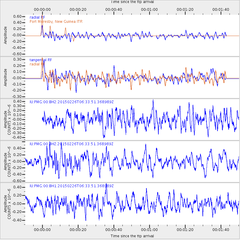
PMG Port Moresby, New Guinea - Earthquake Result Viewer
*The percent match for this event was below the threshold and hence no stack was calculated.
| Earthquake location: |
Tonga Islands |
| Earthquake latitude/longitude: |
-20.2/-173.5 |
| Earthquake time(UTC): |
2015/02/26 (057) 06:26:54 GMT |
| Earthquake Depth: |
25 km |
| Earthquake Magnitude: |
5.4 MW |
| Earthquake Catalog/Contributor: |
ISC/ISC |
|
| Network: |
IU Global Seismograph Network (GSN - IRIS/USGS) |
| Station: |
PMG Port Moresby, New Guinea |
| Lat/Lon: |
9.40 S/147.16 E |
| Elevation: |
90 m |
|
| Distance: |
39.4 deg |
| Az: |
279.918 deg |
| Baz: |
110.332 deg |
| Ray Param: |
$rayparam |
*The percent match for this event was below the threshold and hence was not used in the summary stack. |
|
| Radial Match: |
48.956467 % |
| Radial Bump: |
400 |
| Transverse Match: |
51.081882 % |
| Transverse Bump: |
400 |
| SOD ConfigId: |
7019011 |
| Insert Time: |
2019-04-17 02:16:54.052 +0000 |
| GWidth: |
2.5 |
| Max Bumps: |
400 |
| Tol: |
0.001 |
|
Signal To Noise
| Channel | StoN | STA | LTA |
| IU:PMG:00:BHZ:20150226T06:33:51.368989Z | 2.5030975 | 2.538732E-7 | 1.0142361E-7 |
| IU:PMG:00:BH1:20150226T06:33:51.368989Z | 0.97166014 | 1.313443E-7 | 1.3517514E-7 |
| IU:PMG:00:BH2:20150226T06:33:51.368989Z | 1.6808461 | 1.8051146E-7 | 1.0739322E-7 |
| Arrivals |
| Ps | |
| PpPs | |
| PsPs/PpSs | |


