You are here: Home > Network List > TA - USArray Transportable Network (new EarthScope stations) Stations List
> Station R11A Troy Canyon, Currant, NV, USA > Earthquake Result Viewer
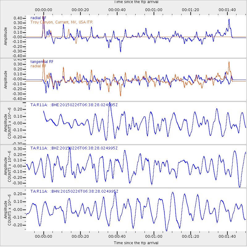
R11A Troy Canyon, Currant, NV, USA - Earthquake Result Viewer
*The percent match for this event was below the threshold and hence no stack was calculated.
| Earthquake location: |
Tonga Islands |
| Earthquake latitude/longitude: |
-20.2/-173.5 |
| Earthquake time(UTC): |
2015/02/26 (057) 06:26:54 GMT |
| Earthquake Depth: |
25 km |
| Earthquake Magnitude: |
5.4 MW |
| Earthquake Catalog/Contributor: |
ISC/ISC |
|
| Network: |
TA USArray Transportable Network (new EarthScope stations) |
| Station: |
R11A Troy Canyon, Currant, NV, USA |
| Lat/Lon: |
38.35 N/115.59 W |
| Elevation: |
1756 m |
|
| Distance: |
79.6 deg |
| Az: |
42.633 deg |
| Baz: |
234.01 deg |
| Ray Param: |
$rayparam |
*The percent match for this event was below the threshold and hence was not used in the summary stack. |
|
| Radial Match: |
62.561584 % |
| Radial Bump: |
400 |
| Transverse Match: |
53.86329 % |
| Transverse Bump: |
400 |
| SOD ConfigId: |
7019011 |
| Insert Time: |
2019-04-17 02:18:42.081 +0000 |
| GWidth: |
2.5 |
| Max Bumps: |
400 |
| Tol: |
0.001 |
|
Signal To Noise
| Channel | StoN | STA | LTA |
| TA:R11A: :BHZ:20150226T06:38:28.024995Z | 2.326904 | 1.491008E-7 | 6.407691E-8 |
| TA:R11A: :BHN:20150226T06:38:28.024995Z | 0.75535095 | 6.50956E-8 | 8.6179284E-8 |
| TA:R11A: :BHE:20150226T06:38:28.024995Z | 2.9271348 | 1.3727974E-7 | 4.6899014E-8 |
| Arrivals |
| Ps | |
| PpPs | |
| PsPs/PpSs | |


