You are here: Home > Network List > CI - Caltech Regional Seismic Network Stations List
> Station MPM Manuel Prospect Mine, California, USA > Earthquake Result Viewer
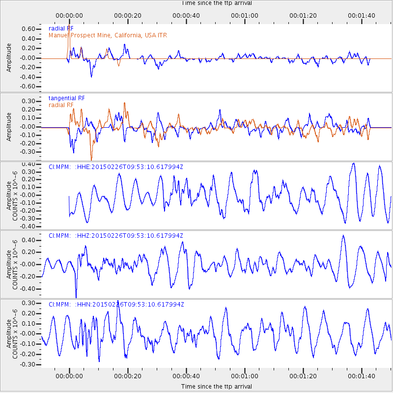
MPM Manuel Prospect Mine, California, USA - Earthquake Result Viewer
*The percent match for this event was below the threshold and hence no stack was calculated.
| Earthquake location: |
Andreanof Islands, Aleutian Is. |
| Earthquake latitude/longitude: |
50.1/-175.8 |
| Earthquake time(UTC): |
2015/02/26 (057) 09:45:37 GMT |
| Earthquake Depth: |
24 km |
| Earthquake Magnitude: |
5.2 MW |
| Earthquake Catalog/Contributor: |
ISC/ISC |
|
| Network: |
CI Caltech Regional Seismic Network |
| Station: |
MPM Manuel Prospect Mine, California, USA |
| Lat/Lon: |
36.06 N/117.49 W |
| Elevation: |
185 m |
|
| Distance: |
43.8 deg |
| Az: |
85.671 deg |
| Baz: |
307.558 deg |
| Ray Param: |
$rayparam |
*The percent match for this event was below the threshold and hence was not used in the summary stack. |
|
| Radial Match: |
44.532288 % |
| Radial Bump: |
400 |
| Transverse Match: |
54.677654 % |
| Transverse Bump: |
400 |
| SOD ConfigId: |
7019011 |
| Insert Time: |
2019-04-17 02:22:08.351 +0000 |
| GWidth: |
2.5 |
| Max Bumps: |
400 |
| Tol: |
0.001 |
|
Signal To Noise
| Channel | StoN | STA | LTA |
| CI:MPM: :HHZ:20150226T09:53:10.617994Z | 1.3075324 | 1.6510742E-7 | 1.2627406E-7 |
| CI:MPM: :HHN:20150226T09:53:10.617994Z | 0.7928364 | 1.1392451E-7 | 1.4369232E-7 |
| CI:MPM: :HHE:20150226T09:53:10.617994Z | 1.0159068 | 1.5045806E-7 | 1.4810222E-7 |
| Arrivals |
| Ps | |
| PpPs | |
| PsPs/PpSs | |


