You are here: Home > Network List > TA - USArray Transportable Network (new EarthScope stations) Stations List
> Station H17A Grant Village (NPS), Yellowstone Nt. Park, WY, USA > Earthquake Result Viewer
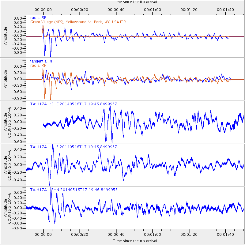
H17A Grant Village (NPS), Yellowstone Nt. Park, WY, USA - Earthquake Result Viewer
*The percent match for this event was below the threshold and hence no stack was calculated.
| Earthquake location: |
Northern Chile |
| Earthquake latitude/longitude: |
-23.5/-68.6 |
| Earthquake time(UTC): |
2014/05/16 (136) 17:08:32 GMT |
| Earthquake Depth: |
103 km |
| Earthquake Magnitude: |
5.5 MWR |
| Earthquake Catalog/Contributor: |
NEIC PDE/NEIC COMCAT |
|
| Network: |
TA USArray Transportable Network (new EarthScope stations) |
| Station: |
H17A Grant Village (NPS), Yellowstone Nt. Park, WY, USA |
| Lat/Lon: |
44.40 N/110.58 W |
| Elevation: |
2400 m |
|
| Distance: |
77.7 deg |
| Az: |
330.596 deg |
| Baz: |
141.027 deg |
| Ray Param: |
$rayparam |
*The percent match for this event was below the threshold and hence was not used in the summary stack. |
|
| Radial Match: |
80.00597 % |
| Radial Bump: |
400 |
| Transverse Match: |
70.25576 % |
| Transverse Bump: |
400 |
| SOD ConfigId: |
626651 |
| Insert Time: |
2014-05-30 17:50:53.705 +0000 |
| GWidth: |
2.5 |
| Max Bumps: |
400 |
| Tol: |
0.001 |
|
Signal To Noise
| Channel | StoN | STA | LTA |
| TA:H17A: :BHZ:20140516T17:19:46.849995Z | 1.9646244 | 2.0345458E-7 | 1.03559024E-7 |
| TA:H17A: :BHN:20140516T17:19:46.849995Z | 4.7355456 | 3.1008554E-7 | 6.548042E-8 |
| TA:H17A: :BHE:20140516T17:19:46.849995Z | 2.597892 | 2.54159E-7 | 9.783278E-8 |
| Arrivals |
| Ps | |
| PpPs | |
| PsPs/PpSs | |


