You are here: Home > Network List > II - Global Seismograph Network (GSN - IRIS/IDA) Stations List
> Station KURK Kurchatov, Kazakhstan > Earthquake Result Viewer
KURK Kurchatov, Kazakhstan - Earthquake Result Viewer

| Earthquake location: |
Northern Molucca Sea |
| Earthquake latitude/longitude: |
1.1/126.3 |
| Earthquake time(UTC): |
2007/01/21 (021) 11:27:45 GMT |
| Earthquake Depth: |
22 km |
| Earthquake Magnitude: |
6.7 MB, 7.3 MS, 7.5 MW, 7.3 MW |
| Earthquake Catalog/Contributor: |
WHDF/NEIC |
|
| Network: |
II Global Seismograph Network (GSN - IRIS/IDA) |
| Station: |
KURK Kurchatov, Kazakhstan |
| Lat/Lon: |
50.72 N/78.62 E |
| Elevation: |
184 m |
|
| Distance: |
63.7 deg |
| Az: |
328.402 deg |
| Baz: |
124.507 deg |
| Ray Param: |
0.05934927 |
| Estimated Moho Depth: |
40.75 km |
| Estimated Crust Vp/Vs: |
1.79 |
| Assumed Crust Vp: |
6.552 km/s |
| Estimated Crust Vs: |
3.661 km/s |
| Estimated Crust Poisson's Ratio: |
0.27 |
|
| Radial Match: |
98.972916 % |
| Radial Bump: |
263 |
| Transverse Match: |
93.80081 % |
| Transverse Bump: |
400 |
| SOD ConfigId: |
2564 |
| Insert Time: |
2010-03-01 22:19:49.795 +0000 |
| GWidth: |
2.5 |
| Max Bumps: |
400 |
| Tol: |
0.001 |
|
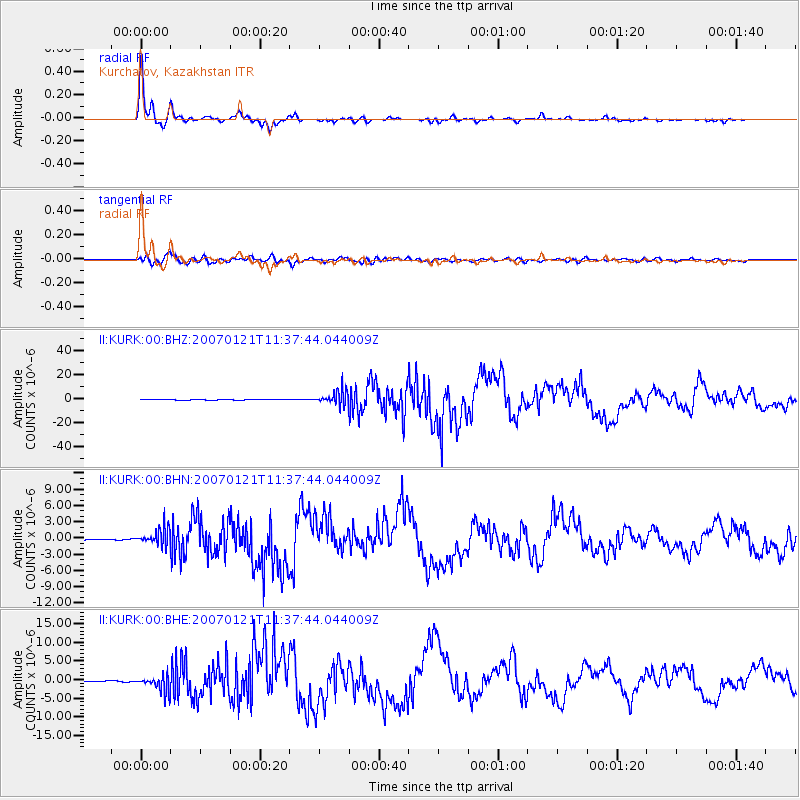
Signal To Noise
| Channel | StoN | STA | LTA |
| II:KURK:00:BHN:20070121T11:37:44.044009Z | 16.52764 | 1.5833997E-6 | 9.580313E-8 |
| II:KURK:00:BHE:20070121T11:37:44.044009Z | 24.06169 | 2.2416127E-6 | 9.316108E-8 |
| II:KURK:00:BHZ:20070121T11:37:44.044009Z | 51.068195 | 5.8826945E-6 | 1.1519291E-7 |
| Arrivals |
| Ps | 5.1 SECOND |
| PpPs | 17 SECOND |
| PsPs/PpSs | 22 SECOND |


