You are here: Home > Network List > TA - USArray Transportable Network (new EarthScope stations) Stations List
> Station I48A Sherman Twp, MI, USA > Earthquake Result Viewer
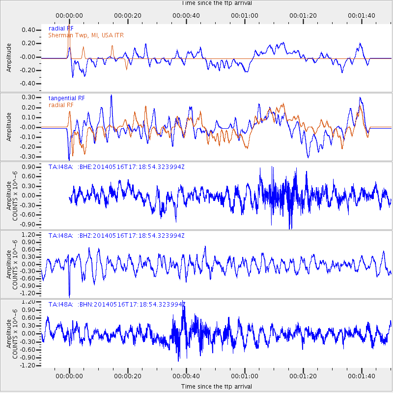
I48A Sherman Twp, MI, USA - Earthquake Result Viewer
*The percent match for this event was below the threshold and hence no stack was calculated.
| Earthquake location: |
Northern Chile |
| Earthquake latitude/longitude: |
-23.5/-68.6 |
| Earthquake time(UTC): |
2014/05/16 (136) 17:08:32 GMT |
| Earthquake Depth: |
103 km |
| Earthquake Magnitude: |
5.5 MWR |
| Earthquake Catalog/Contributor: |
NEIC PDE/NEIC COMCAT |
|
| Network: |
TA USArray Transportable Network (new EarthScope stations) |
| Station: |
I48A Sherman Twp, MI, USA |
| Lat/Lon: |
44.19 N/83.70 W |
| Elevation: |
192 m |
|
| Distance: |
68.7 deg |
| Az: |
348.379 deg |
| Baz: |
165.1 deg |
| Ray Param: |
$rayparam |
*The percent match for this event was below the threshold and hence was not used in the summary stack. |
|
| Radial Match: |
49.38151 % |
| Radial Bump: |
400 |
| Transverse Match: |
61.05358 % |
| Transverse Bump: |
400 |
| SOD ConfigId: |
626651 |
| Insert Time: |
2014-05-30 17:52:28.175 +0000 |
| GWidth: |
2.5 |
| Max Bumps: |
400 |
| Tol: |
0.001 |
|
Signal To Noise
| Channel | StoN | STA | LTA |
| TA:I48A: :BHZ:20140516T17:18:54.323994Z | 1.1477649 | 4.0937027E-7 | 3.5666736E-7 |
| TA:I48A: :BHN:20140516T17:18:54.323994Z | 0.79810834 | 2.3432632E-7 | 2.9360214E-7 |
| TA:I48A: :BHE:20140516T17:18:54.323994Z | 2.2253454 | 3.7305432E-7 | 1.6763885E-7 |
| Arrivals |
| Ps | |
| PpPs | |
| PsPs/PpSs | |


