You are here: Home > Network List > TA - USArray Transportable Network (new EarthScope stations) Stations List
> Station Q56A Snyder Ridge, Maysville, WV, USA > Earthquake Result Viewer
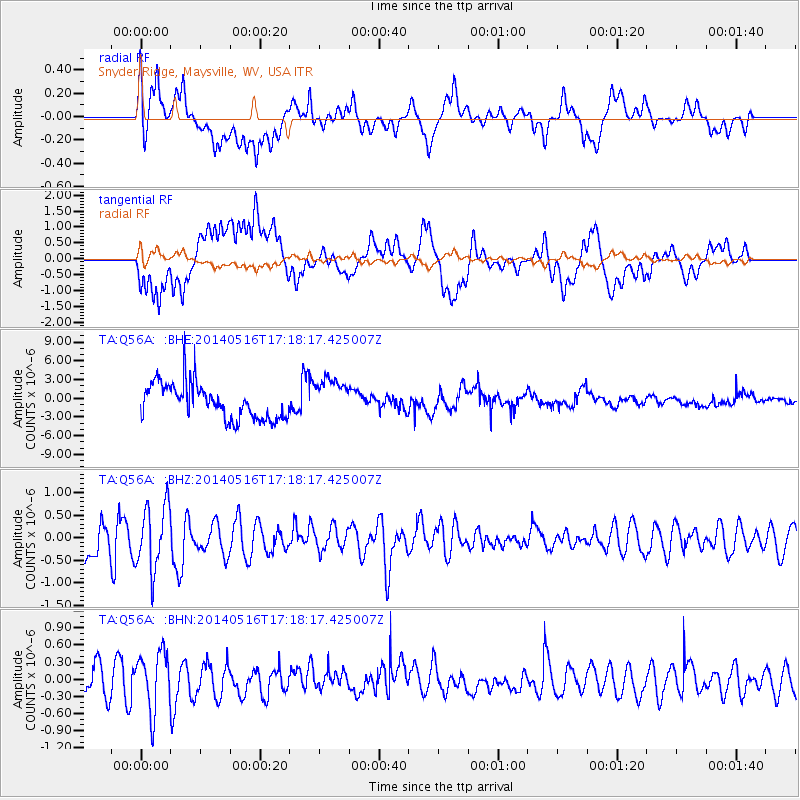
Q56A Snyder Ridge, Maysville, WV, USA - Earthquake Result Viewer
*The percent match for this event was below the threshold and hence no stack was calculated.
| Earthquake location: |
Northern Chile |
| Earthquake latitude/longitude: |
-23.5/-68.6 |
| Earthquake time(UTC): |
2014/05/16 (136) 17:08:32 GMT |
| Earthquake Depth: |
103 km |
| Earthquake Magnitude: |
5.5 MWR |
| Earthquake Catalog/Contributor: |
NEIC PDE/NEIC COMCAT |
|
| Network: |
TA USArray Transportable Network (new EarthScope stations) |
| Station: |
Q56A Snyder Ridge, Maysville, WV, USA |
| Lat/Lon: |
39.04 N/79.19 W |
| Elevation: |
430 m |
|
| Distance: |
63.0 deg |
| Az: |
350.736 deg |
| Baz: |
169.057 deg |
| Ray Param: |
$rayparam |
*The percent match for this event was below the threshold and hence was not used in the summary stack. |
|
| Radial Match: |
59.817192 % |
| Radial Bump: |
400 |
| Transverse Match: |
53.289288 % |
| Transverse Bump: |
400 |
| SOD ConfigId: |
626651 |
| Insert Time: |
2014-05-30 17:57:56.513 +0000 |
| GWidth: |
2.5 |
| Max Bumps: |
400 |
| Tol: |
0.001 |
|
Signal To Noise
| Channel | StoN | STA | LTA |
| TA:Q56A: :BHZ:20140516T17:18:17.425007Z | 1.9124049 | 7.1366514E-7 | 3.7317682E-7 |
| TA:Q56A: :BHN:20140516T17:18:17.425007Z | 1.4913039 | 5.1781404E-7 | 3.472223E-7 |
| TA:Q56A: :BHE:20140516T17:18:17.425007Z | 1.15132 | 3.2399064E-6 | 2.8140798E-6 |
| Arrivals |
| Ps | |
| PpPs | |
| PsPs/PpSs | |


