You are here: Home > Network List > TA - USArray Transportable Network (new EarthScope stations) Stations List
> Station R11A Troy Canyon, Currant, NV, USA > Earthquake Result Viewer
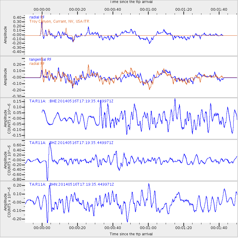
R11A Troy Canyon, Currant, NV, USA - Earthquake Result Viewer
*The percent match for this event was below the threshold and hence no stack was calculated.
| Earthquake location: |
Northern Chile |
| Earthquake latitude/longitude: |
-23.5/-68.6 |
| Earthquake time(UTC): |
2014/05/16 (136) 17:08:32 GMT |
| Earthquake Depth: |
103 km |
| Earthquake Magnitude: |
5.5 MWR |
| Earthquake Catalog/Contributor: |
NEIC PDE/NEIC COMCAT |
|
| Network: |
TA USArray Transportable Network (new EarthScope stations) |
| Station: |
R11A Troy Canyon, Currant, NV, USA |
| Lat/Lon: |
38.35 N/115.59 W |
| Elevation: |
1756 m |
|
| Distance: |
75.7 deg |
| Az: |
323.585 deg |
| Baz: |
136.104 deg |
| Ray Param: |
$rayparam |
*The percent match for this event was below the threshold and hence was not used in the summary stack. |
|
| Radial Match: |
64.72979 % |
| Radial Bump: |
400 |
| Transverse Match: |
57.11668 % |
| Transverse Bump: |
400 |
| SOD ConfigId: |
626651 |
| Insert Time: |
2014-05-30 17:58:05.226 +0000 |
| GWidth: |
2.5 |
| Max Bumps: |
400 |
| Tol: |
0.001 |
|
Signal To Noise
| Channel | StoN | STA | LTA |
| TA:R11A: :BHZ:20140516T17:19:35.449971Z | 7.426019 | 3.845213E-7 | 5.178027E-8 |
| TA:R11A: :BHN:20140516T17:19:35.449971Z | 2.8203063 | 1.1599361E-7 | 4.112802E-8 |
| TA:R11A: :BHE:20140516T17:19:35.449971Z | 1.765637 | 6.512642E-8 | 3.688551E-8 |
| Arrivals |
| Ps | |
| PpPs | |
| PsPs/PpSs | |


