You are here: Home > Network List > TA - USArray Transportable Network (new EarthScope stations) Stations List
> Station O03E Paynes Creek, CA, USA > Earthquake Result Viewer
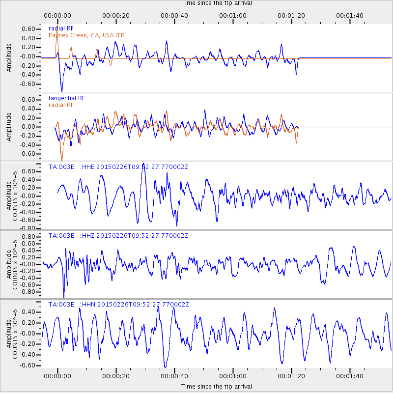
O03E Paynes Creek, CA, USA - Earthquake Result Viewer
*The percent match for this event was below the threshold and hence no stack was calculated.
| Earthquake location: |
Andreanof Islands, Aleutian Is. |
| Earthquake latitude/longitude: |
50.1/-175.8 |
| Earthquake time(UTC): |
2015/02/26 (057) 09:45:37 GMT |
| Earthquake Depth: |
24 km |
| Earthquake Magnitude: |
5.2 MW |
| Earthquake Catalog/Contributor: |
ISC/ISC |
|
| Network: |
TA USArray Transportable Network (new EarthScope stations) |
| Station: |
O03E Paynes Creek, CA, USA |
| Lat/Lon: |
40.29 N/121.80 W |
| Elevation: |
967 m |
|
| Distance: |
38.5 deg |
| Az: |
83.426 deg |
| Baz: |
303.209 deg |
| Ray Param: |
$rayparam |
*The percent match for this event was below the threshold and hence was not used in the summary stack. |
|
| Radial Match: |
60.971634 % |
| Radial Bump: |
400 |
| Transverse Match: |
68.34537 % |
| Transverse Bump: |
400 |
| SOD ConfigId: |
7019011 |
| Insert Time: |
2019-04-17 02:27:40.725 +0000 |
| GWidth: |
2.5 |
| Max Bumps: |
400 |
| Tol: |
0.001 |
|
Signal To Noise
| Channel | StoN | STA | LTA |
| TA:O03E: :HHZ:20150226T09:52:27.770002Z | 1.8218794 | 3.331638E-7 | 1.828682E-7 |
| TA:O03E: :HHN:20150226T09:52:27.770002Z | 0.7074437 | 2.3843768E-7 | 3.3704117E-7 |
| TA:O03E: :HHE:20150226T09:52:27.770002Z | 1.8860961 | 4.7535005E-7 | 2.5202854E-7 |
| Arrivals |
| Ps | |
| PpPs | |
| PsPs/PpSs | |


