You are here: Home > Network List > TA - USArray Transportable Network (new EarthScope stations) Stations List
> Station G59A Clarenceville, QC, USA > Earthquake Result Viewer
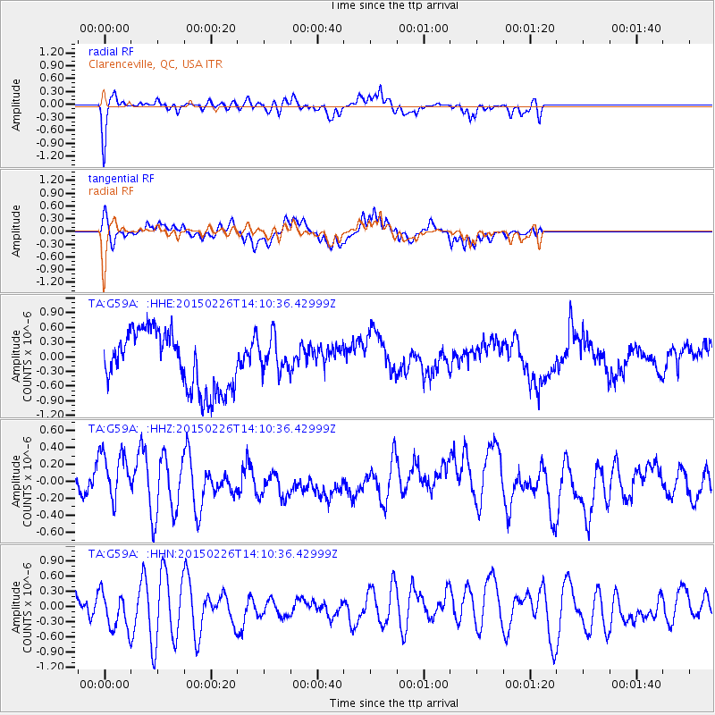
G59A Clarenceville, QC, USA - Earthquake Result Viewer
*The percent match for this event was below the threshold and hence no stack was calculated.
| Earthquake location: |
Hindu Kush Region, Afghanistan |
| Earthquake latitude/longitude: |
36.4/71.0 |
| Earthquake time(UTC): |
2015/02/26 (057) 13:58:11 GMT |
| Earthquake Depth: |
140 km |
| Earthquake Magnitude: |
4.7 mb |
| Earthquake Catalog/Contributor: |
ISC/ISC |
|
| Network: |
TA USArray Transportable Network (new EarthScope stations) |
| Station: |
G59A Clarenceville, QC, USA |
| Lat/Lon: |
45.08 N/73.18 W |
| Elevation: |
36 m |
|
| Distance: |
92.7 deg |
| Az: |
335.459 deg |
| Baz: |
28.234 deg |
| Ray Param: |
$rayparam |
*The percent match for this event was below the threshold and hence was not used in the summary stack. |
|
| Radial Match: |
75.54486 % |
| Radial Bump: |
371 |
| Transverse Match: |
52.25705 % |
| Transverse Bump: |
400 |
| SOD ConfigId: |
7019011 |
| Insert Time: |
2019-04-17 02:34:40.542 +0000 |
| GWidth: |
2.5 |
| Max Bumps: |
400 |
| Tol: |
0.001 |
|
Signal To Noise
| Channel | StoN | STA | LTA |
| TA:G59A: :HHZ:20150226T14:10:36.42999Z | 1.3129897 | 2.908109E-7 | 2.2148758E-7 |
| TA:G59A: :HHN:20150226T14:10:36.42999Z | 1.1131272 | 3.845674E-7 | 3.4548376E-7 |
| TA:G59A: :HHE:20150226T14:10:36.42999Z | 0.5942039 | 3.4979323E-7 | 5.8867545E-7 |
| Arrivals |
| Ps | |
| PpPs | |
| PsPs/PpSs | |


