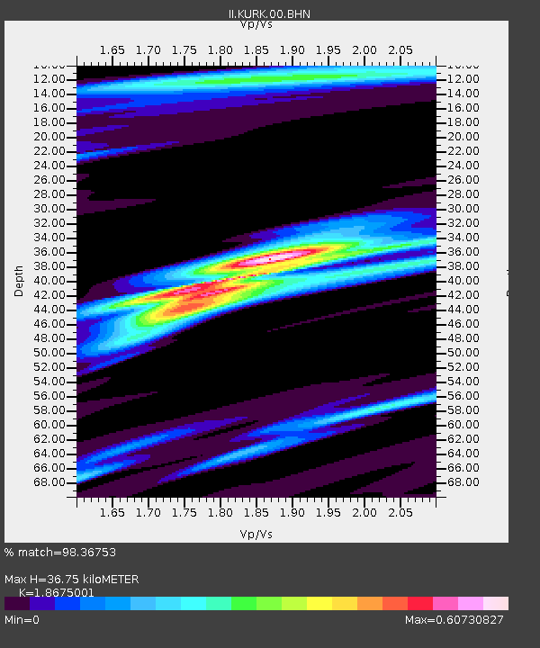
KURK Kurchatov, Kazakhstan - Earthquake Result Viewer
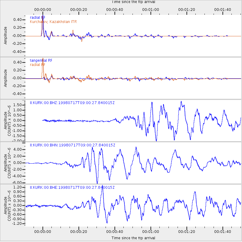
Earthquake location: Near N Coast Of New Guinea, P.N.G.
Earthquake latitude/longitude: -3.0/141.9
Earthquake time(UTC): 1998/07/17 (198) 08:49:13 GMT
Earthquake Depth: 10 km
Earthquake Magnitude: 5.8 MB, 7.1 MS, 7.1 UNKNOWN, 6.4 ME
Earthquake Catalog/Contributor: WHDF/NEIC
Network: II Global Seismograph Network (GSN - IRIS/IDA)
Station: KURK Kurchatov, Kazakhstan
Lat/Lon: 50.72 N/78.62 E
Elevation: 184 m
Distance: 75.8 deg
Az: 324.133 deg
Baz: 113.011 deg
Ray Param: 0.05143611
Estimated Moho Depth: 36.75 km
Estimated Crust Vp/Vs: 1.87
Assumed Crust Vp: 6.552 km/s
Estimated Crust Vs: 3.509 km/s
Estimated Crust Poisson's Ratio: 0.30
Radial Match: 98.36753 %
Radial Bump: 248
Transverse Match: 89.75491 %
Transverse Bump: 400
SOD ConfigId: 4480
Insert Time: 2010-03-01 22:21:13.998 +0000
GWidth: 2.5
Max Bumps: 400
Tol: 0.001

Signal To Noise

ChannelStoNSTALTA
II:KURK:00:BHN:19980717T09:00:27.840015Z2.47620751.3864282E-75.5989982E-8
II:KURK:00:BHE:19980717T09:00:27.840015Z0.41621881.9522107E-84.6903473E-8
II:KURK:00:BHZ:19980717T09:00:27.840015Z1.395244.9827054E-83.5712173E-8
Arrivals
Ps5.0 SECOND
PpPs16 SECOND
PsPs/PpSs21 SECOND