You are here: Home > Network List > TA - USArray Transportable Network (new EarthScope stations) Stations List
> Station G59A Clarenceville, QC, USA > Earthquake Result Viewer
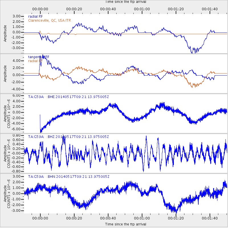
G59A Clarenceville, QC, USA - Earthquake Result Viewer
*The percent match for this event was below the threshold and hence no stack was calculated.
| Earthquake location: |
Near Coast Of Northern Chile |
| Earthquake latitude/longitude: |
-20.0/-70.9 |
| Earthquake time(UTC): |
2014/05/17 (137) 09:11:06 GMT |
| Earthquake Depth: |
13 km |
| Earthquake Magnitude: |
5.5 MB |
| Earthquake Catalog/Contributor: |
NEIC PDE/NEIC COMCAT |
|
| Network: |
TA USArray Transportable Network (new EarthScope stations) |
| Station: |
G59A Clarenceville, QC, USA |
| Lat/Lon: |
45.08 N/73.18 W |
| Elevation: |
36 m |
|
| Distance: |
64.8 deg |
| Az: |
358.217 deg |
| Baz: |
177.633 deg |
| Ray Param: |
$rayparam |
*The percent match for this event was below the threshold and hence was not used in the summary stack. |
|
| Radial Match: |
38.14456 % |
| Radial Bump: |
400 |
| Transverse Match: |
35.87022 % |
| Transverse Bump: |
400 |
| SOD ConfigId: |
626651 |
| Insert Time: |
2014-05-31 09:47:12.686 +0000 |
| GWidth: |
2.5 |
| Max Bumps: |
400 |
| Tol: |
0.001 |
|
Signal To Noise
| Channel | StoN | STA | LTA |
| TA:G59A: :BHZ:20140517T09:21:13.975005Z | 1.2414843 | 2.820609E-7 | 2.2719652E-7 |
| TA:G59A: :BHN:20140517T09:21:13.975005Z | 2.5179086 | 1.8081912E-6 | 7.181322E-7 |
| TA:G59A: :BHE:20140517T09:21:13.975005Z | 0.9033478 | 1.9121276E-6 | 2.1167125E-6 |
| Arrivals |
| Ps | |
| PpPs | |
| PsPs/PpSs | |


