You are here: Home > Network List > TA - USArray Transportable Network (new EarthScope stations) Stations List
> Station MSTX Muleshoe, TX, USA > Earthquake Result Viewer
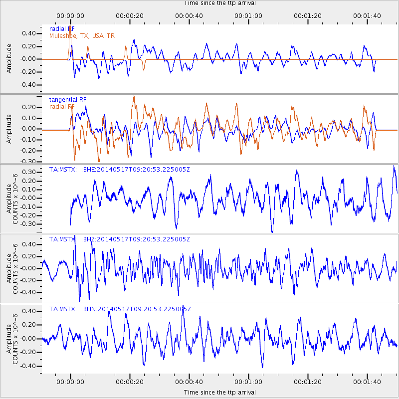
MSTX Muleshoe, TX, USA - Earthquake Result Viewer
*The percent match for this event was below the threshold and hence no stack was calculated.
| Earthquake location: |
Near Coast Of Northern Chile |
| Earthquake latitude/longitude: |
-20.0/-70.9 |
| Earthquake time(UTC): |
2014/05/17 (137) 09:11:06 GMT |
| Earthquake Depth: |
13 km |
| Earthquake Magnitude: |
5.5 MB |
| Earthquake Catalog/Contributor: |
NEIC PDE/NEIC COMCAT |
|
| Network: |
TA USArray Transportable Network (new EarthScope stations) |
| Station: |
MSTX Muleshoe, TX, USA |
| Lat/Lon: |
33.97 N/102.77 W |
| Elevation: |
1167 m |
|
| Distance: |
61.7 deg |
| Az: |
330.101 deg |
| Baz: |
145.667 deg |
| Ray Param: |
$rayparam |
*The percent match for this event was below the threshold and hence was not used in the summary stack. |
|
| Radial Match: |
58.072132 % |
| Radial Bump: |
400 |
| Transverse Match: |
51.94845 % |
| Transverse Bump: |
400 |
| SOD ConfigId: |
626651 |
| Insert Time: |
2014-05-31 09:51:36.225 +0000 |
| GWidth: |
2.5 |
| Max Bumps: |
400 |
| Tol: |
0.001 |
|
Signal To Noise
| Channel | StoN | STA | LTA |
| TA:MSTX: :BHZ:20140517T09:20:53.225005Z | 2.8837366 | 2.4017103E-7 | 8.328467E-8 |
| TA:MSTX: :BHN:20140517T09:20:53.225005Z | 0.88378584 | 9.9212485E-8 | 1.1225851E-7 |
| TA:MSTX: :BHE:20140517T09:20:53.225005Z | 1.4679788 | 1.4193382E-7 | 9.6686556E-8 |
| Arrivals |
| Ps | |
| PpPs | |
| PsPs/PpSs | |


