You are here: Home > Network List > TA - USArray Transportable Network (new EarthScope stations) Stations List
> Station 121A Cookes Peak, Deming, NM, USA > Earthquake Result Viewer
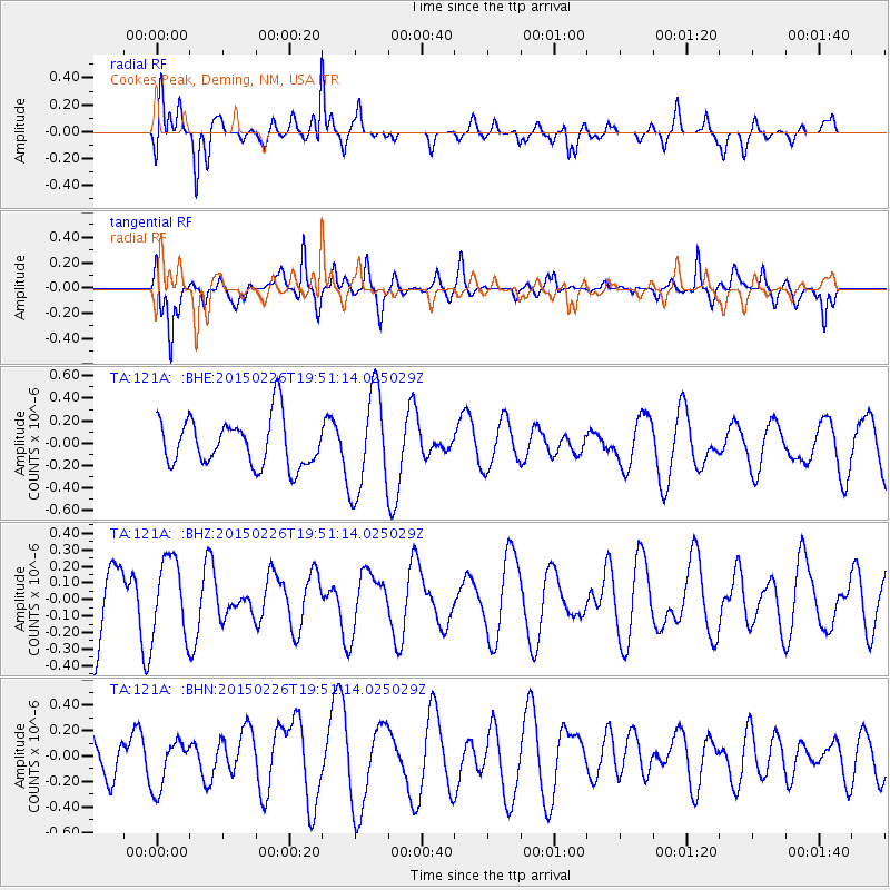
121A Cookes Peak, Deming, NM, USA - Earthquake Result Viewer
*The percent match for this event was below the threshold and hence no stack was calculated.
| Earthquake location: |
South Of Fiji Islands |
| Earthquake latitude/longitude: |
-25.3/-176.4 |
| Earthquake time(UTC): |
2015/02/26 (057) 19:39:03 GMT |
| Earthquake Depth: |
35 km |
| Earthquake Magnitude: |
4.3 mb |
| Earthquake Catalog/Contributor: |
ISC/ISC |
|
| Network: |
TA USArray Transportable Network (new EarthScope stations) |
| Station: |
121A Cookes Peak, Deming, NM, USA |
| Lat/Lon: |
32.53 N/107.79 W |
| Elevation: |
1652 m |
|
| Distance: |
87.1 deg |
| Az: |
51.97 deg |
| Baz: |
237.549 deg |
| Ray Param: |
$rayparam |
*The percent match for this event was below the threshold and hence was not used in the summary stack. |
|
| Radial Match: |
60.62802 % |
| Radial Bump: |
384 |
| Transverse Match: |
55.89018 % |
| Transverse Bump: |
349 |
| SOD ConfigId: |
7019011 |
| Insert Time: |
2019-04-17 02:41:43.577 +0000 |
| GWidth: |
2.5 |
| Max Bumps: |
400 |
| Tol: |
0.001 |
|
Signal To Noise
| Channel | StoN | STA | LTA |
| TA:121A: :BHZ:20150226T19:51:14.025029Z | 1.1321577 | 2.3256341E-7 | 2.054161E-7 |
| TA:121A: :BHN:20150226T19:51:14.025029Z | 1.461668 | 1.9031123E-7 | 1.302014E-7 |
| TA:121A: :BHE:20150226T19:51:14.025029Z | 2.1109118 | 4.4859965E-7 | 2.1251462E-7 |
| Arrivals |
| Ps | |
| PpPs | |
| PsPs/PpSs | |


