You are here: Home > Network List > II - Global Seismograph Network (GSN - IRIS/IDA) Stations List
> Station KURK Kurchatov, Kazakhstan > Earthquake Result Viewer
KURK Kurchatov, Kazakhstan - Earthquake Result Viewer
| Earthquake location: |
New Ireland Region, P.N.G. |
| Earthquake latitude/longitude: |
-5.2/153.7 |
| Earthquake time(UTC): |
2009/06/23 (174) 14:19:17 GMT |
| Earthquake Depth: |
65 km |
| Earthquake Magnitude: |
5.5 MB |
| Earthquake Catalog/Contributor: |
WHDF/NEIC |
|
| Network: |
II Global Seismograph Network (GSN - IRIS/IDA) |
| Station: |
KURK Kurchatov, Kazakhstan |
| Lat/Lon: |
50.72 N/78.62 E |
| Elevation: |
184 m |
|
| Distance: |
84.6 deg |
| Az: |
321.904 deg |
| Baz: |
104.854 deg |
| Ray Param: |
0.045219336 |
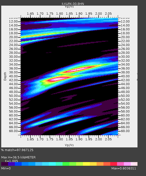
| Estimated Moho Depth: |
36.5 km |
| Estimated Crust Vp/Vs: |
1.88 |
| Assumed Crust Vp: |
6.552 km/s |
| Estimated Crust Vs: |
3.476 km/s |
| Estimated Crust Poisson's Ratio: |
0.30 |
|
| Radial Match: |
97.967125 % |
| Radial Bump: |
313 |
| Transverse Match: |
95.10401 % |
| Transverse Bump: |
400 |
| SOD ConfigId: |
2648 |
| Insert Time: |
2010-03-01 22:22:01.654 +0000 |
| GWidth: |
2.5 |
| Max Bumps: |
400 |
| Tol: |
0.001 |
|

Signal To Noise
| Channel | StoN | STA | LTA |
| II:KURK:00:BHN:20090623T14:31:13.098013Z | 9.558405 | 5.7534385E-7 | 6.019245E-8 |
| II:KURK:00:BHE:20090623T14:31:13.098013Z | 2.414248 | 7.559041E-8 | 3.1310126E-8 |
| II:KURK:00:BHZ:20090623T14:31:13.098013Z | 4.944514 | 1.8504888E-7 | 3.7425092E-8 |
| Arrivals |
| Ps | 5.0 SECOND |
| PpPs | 16 SECOND |
| PsPs/PpSs | 21 SECOND |


