You are here: Home > Network List > TA - USArray Transportable Network (new EarthScope stations) Stations List
> Station 435B Jarrell, TX, USA > Earthquake Result Viewer
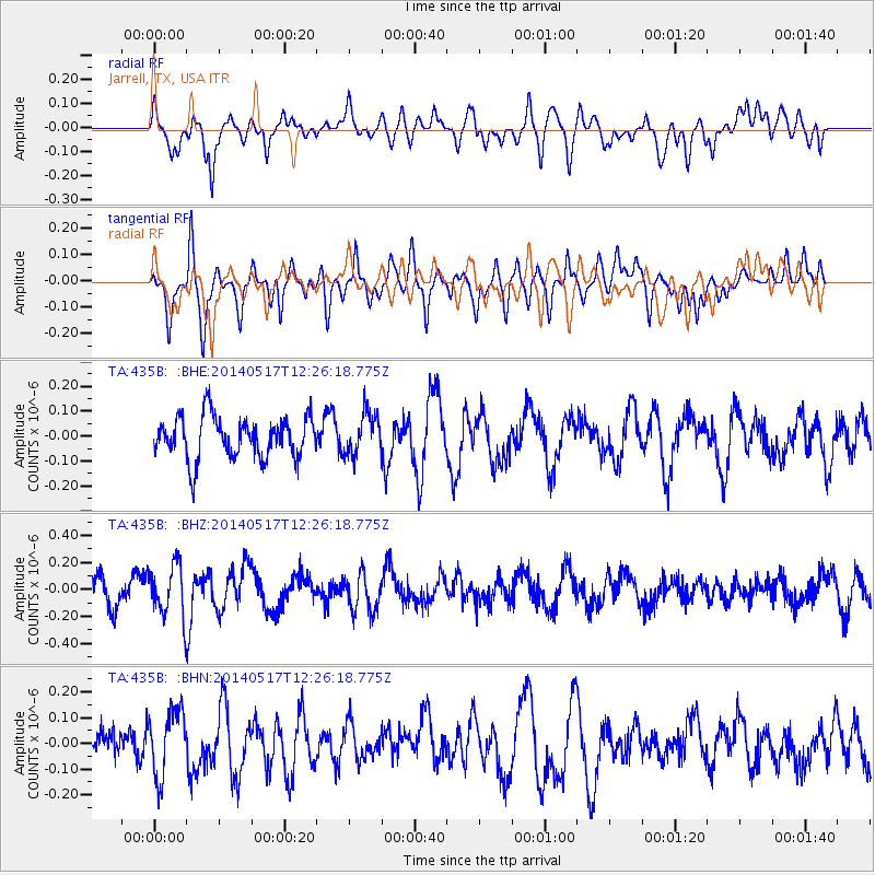
435B Jarrell, TX, USA - Earthquake Result Viewer
*The percent match for this event was below the threshold and hence no stack was calculated.
| Earthquake location: |
Pacific-Antarctic Ridge |
| Earthquake latitude/longitude: |
-54.3/-146.6 |
| Earthquake time(UTC): |
2014/05/17 (137) 12:13:29 GMT |
| Earthquake Depth: |
10 km |
| Earthquake Magnitude: |
5.9 MWP |
| Earthquake Catalog/Contributor: |
NEIC PDE/NEIC COMCAT |
|
| Network: |
TA USArray Transportable Network (new EarthScope stations) |
| Station: |
435B Jarrell, TX, USA |
| Lat/Lon: |
30.78 N/97.58 W |
| Elevation: |
248 m |
|
| Distance: |
94.7 deg |
| Az: |
40.665 deg |
| Baz: |
206.331 deg |
| Ray Param: |
$rayparam |
*The percent match for this event was below the threshold and hence was not used in the summary stack. |
|
| Radial Match: |
60.377434 % |
| Radial Bump: |
400 |
| Transverse Match: |
63.731735 % |
| Transverse Bump: |
344 |
| SOD ConfigId: |
626651 |
| Insert Time: |
2014-05-31 12:32:04.325 +0000 |
| GWidth: |
2.5 |
| Max Bumps: |
400 |
| Tol: |
0.001 |
|
Signal To Noise
| Channel | StoN | STA | LTA |
| TA:435B: :BHZ:20140517T12:26:18.775Z | 2.0412061 | 1.923673E-7 | 9.424197E-8 |
| TA:435B: :BHN:20140517T12:26:18.775Z | 1.5152004 | 1.2799646E-7 | 8.4474934E-8 |
| TA:435B: :BHE:20140517T12:26:18.775Z | 1.0116299 | 8.3818165E-8 | 8.285458E-8 |
| Arrivals |
| Ps | |
| PpPs | |
| PsPs/PpSs | |


