You are here: Home > Network List > US - United States National Seismic Network Stations List
> Station MNTX Cornudas Mountains, Texas, USA > Earthquake Result Viewer
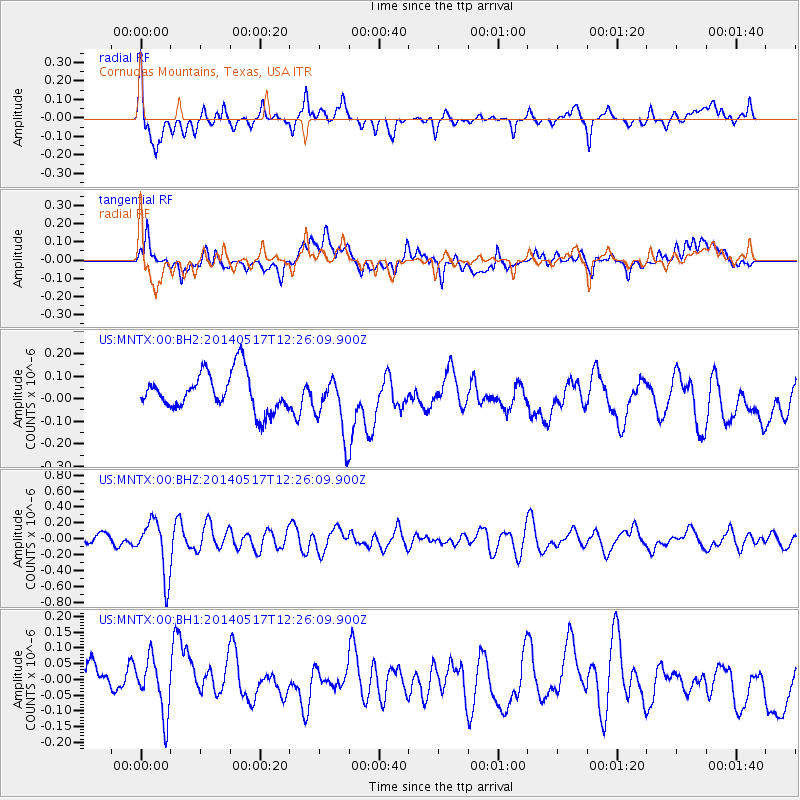
MNTX Cornudas Mountains, Texas, USA - Earthquake Result Viewer
*The percent match for this event was below the threshold and hence no stack was calculated.
| Earthquake location: |
Pacific-Antarctic Ridge |
| Earthquake latitude/longitude: |
-54.3/-146.6 |
| Earthquake time(UTC): |
2014/05/17 (137) 12:13:29 GMT |
| Earthquake Depth: |
10 km |
| Earthquake Magnitude: |
5.9 MWP |
| Earthquake Catalog/Contributor: |
NEIC PDE/NEIC COMCAT |
|
| Network: |
US United States National Seismic Network |
| Station: |
MNTX Cornudas Mountains, Texas, USA |
| Lat/Lon: |
31.70 N/105.38 W |
| Elevation: |
404 m |
|
| Distance: |
92.8 deg |
| Az: |
34.199 deg |
| Baz: |
202.723 deg |
| Ray Param: |
$rayparam |
*The percent match for this event was below the threshold and hence was not used in the summary stack. |
|
| Radial Match: |
73.99102 % |
| Radial Bump: |
400 |
| Transverse Match: |
29.787859 % |
| Transverse Bump: |
400 |
| SOD ConfigId: |
626651 |
| Insert Time: |
2014-05-31 12:33:01.366 +0000 |
| GWidth: |
2.5 |
| Max Bumps: |
400 |
| Tol: |
0.001 |
|
Signal To Noise
| Channel | StoN | STA | LTA |
| US:MNTX:00:BHZ:20140517T12:26:09.900Z | 8.389375 | 3.463973E-7 | 4.129E-8 |
| US:MNTX:00:BH1:20140517T12:26:09.900Z | 1.7494727 | 8.6242274E-8 | 4.929615E-8 |
| US:MNTX:00:BH2:20140517T12:26:09.900Z | 1.5167466 | 1.2674674E-7 | 8.356488E-8 |
| Arrivals |
| Ps | |
| PpPs | |
| PsPs/PpSs | |


