You are here: Home > Network List > TA - USArray Transportable Network (new EarthScope stations) Stations List
> Station J01E Myrtle Point, OR, USA > Earthquake Result Viewer
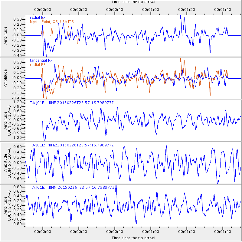
J01E Myrtle Point, OR, USA - Earthquake Result Viewer
*The percent match for this event was below the threshold and hence no stack was calculated.
| Earthquake location: |
New Britain Region, P.N.G. |
| Earthquake latitude/longitude: |
-5.4/152.8 |
| Earthquake time(UTC): |
2015/02/26 (057) 23:44:58 GMT |
| Earthquake Depth: |
37 km |
| Earthquake Magnitude: |
5.0 MW |
| Earthquake Catalog/Contributor: |
ISC/ISC |
|
| Network: |
TA USArray Transportable Network (new EarthScope stations) |
| Station: |
J01E Myrtle Point, OR, USA |
| Lat/Lon: |
43.16 N/123.93 W |
| Elevation: |
128 m |
|
| Distance: |
88.8 deg |
| Az: |
46.622 deg |
| Baz: |
261.477 deg |
| Ray Param: |
$rayparam |
*The percent match for this event was below the threshold and hence was not used in the summary stack. |
|
| Radial Match: |
43.62254 % |
| Radial Bump: |
400 |
| Transverse Match: |
54.275322 % |
| Transverse Bump: |
400 |
| SOD ConfigId: |
7019011 |
| Insert Time: |
2019-04-17 02:52:56.616 +0000 |
| GWidth: |
2.5 |
| Max Bumps: |
400 |
| Tol: |
0.001 |
|
Signal To Noise
| Channel | StoN | STA | LTA |
| TA:J01E: :BHZ:20150226T23:57:16.798977Z | 0.9520043 | 2.732047E-7 | 2.8697843E-7 |
| TA:J01E: :BHN:20150226T23:57:16.798977Z | 0.9934806 | 2.783064E-7 | 2.801327E-7 |
| TA:J01E: :BHE:20150226T23:57:16.798977Z | 1.1243756 | 4.7116174E-7 | 4.19043E-7 |
| Arrivals |
| Ps | |
| PpPs | |
| PsPs/PpSs | |


