You are here: Home > Network List > IC - New China Digital Seismograph Network Stations List
> Station WMQ Urumqi, Xinjiang Province, China > Earthquake Result Viewer
WMQ Urumqi, Xinjiang Province, China - Earthquake Result Viewer
| Earthquake location: |
Off W Coast Of Northern Sumatra |
| Earthquake latitude/longitude: |
4.3/92.7 |
| Earthquake time(UTC): |
2014/05/18 (138) 01:02:29 GMT |
| Earthquake Depth: |
9.8 km |
| Earthquake Magnitude: |
6.2 MWP |
| Earthquake Catalog/Contributor: |
NEIC PDE/NEIC COMCAT |
|
| Network: |
IC New China Digital Seismograph Network |
| Station: |
WMQ Urumqi, Xinjiang Province, China |
| Lat/Lon: |
43.81 N/87.70 E |
| Elevation: |
850 m |
|
| Distance: |
39.6 deg |
| Az: |
354.276 deg |
| Baz: |
172.103 deg |
| Ray Param: |
0.07486671 |
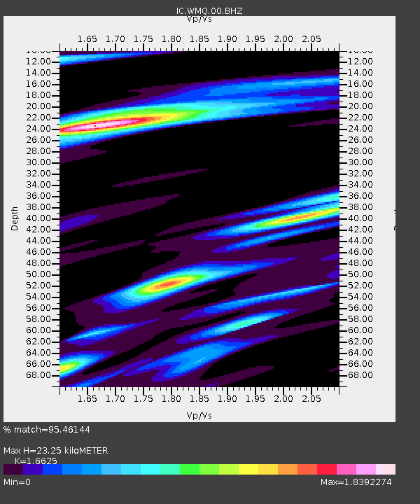
| Estimated Moho Depth: |
23.25 km |
| Estimated Crust Vp/Vs: |
1.66 |
| Assumed Crust Vp: |
6.242 km/s |
| Estimated Crust Vs: |
3.755 km/s |
| Estimated Crust Poisson's Ratio: |
0.22 |
|
| Radial Match: |
95.46144 % |
| Radial Bump: |
369 |
| Transverse Match: |
72.18193 % |
| Transverse Bump: |
400 |
| SOD ConfigId: |
626651 |
| Insert Time: |
2014-06-01 01:19:42.023 +0000 |
| GWidth: |
2.5 |
| Max Bumps: |
400 |
| Tol: |
0.001 |
|
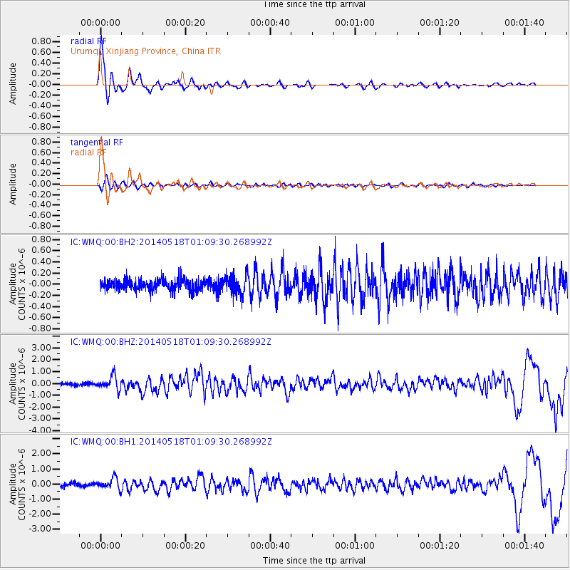
Signal To Noise
| Channel | StoN | STA | LTA |
| IC:WMQ:00:BHZ:20140518T01:09:30.268992Z | 5.76814 | 5.7593E-7 | 9.984675E-8 |
| IC:WMQ:00:BH1:20140518T01:09:30.268992Z | 3.3299148 | 3.6303408E-7 | 1.0902203E-7 |
| IC:WMQ:00:BH2:20140518T01:09:30.268992Z | 1.7863871 | 1.7460862E-7 | 9.7744E-8 |
| Arrivals |
| Ps | 2.6 SECOND |
| PpPs | 9.2 SECOND |
| PsPs/PpSs | 12 SECOND |


