You are here: Home > Network List > UW - Pacific Northwest Regional Seismic Network Stations List
> Station MRBL Marblemount, WA, USA > Earthquake Result Viewer
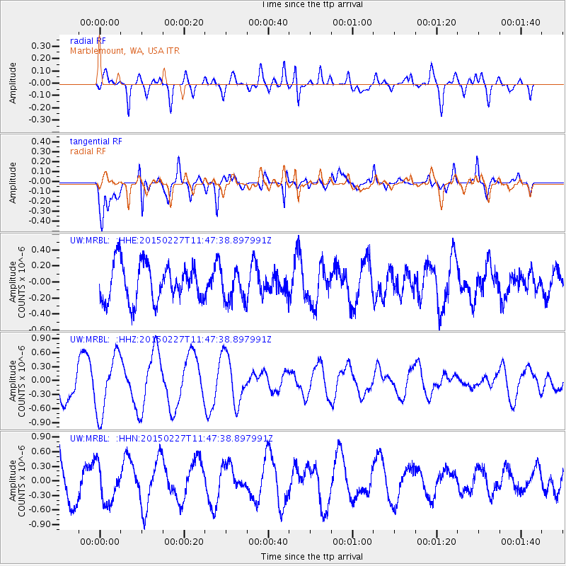
MRBL Marblemount, WA, USA - Earthquake Result Viewer
*The percent match for this event was below the threshold and hence no stack was calculated.
| Earthquake location: |
Solomon Islands |
| Earthquake latitude/longitude: |
-7.1/155.3 |
| Earthquake time(UTC): |
2015/02/27 (058) 11:35:15 GMT |
| Earthquake Depth: |
78 km |
| Earthquake Magnitude: |
5.4 MW |
| Earthquake Catalog/Contributor: |
ISC/ISC |
|
| Network: |
UW Pacific Northwest Regional Seismic Network |
| Station: |
MRBL Marblemount, WA, USA |
| Lat/Lon: |
48.52 N/121.48 W |
| Elevation: |
75 m |
|
| Distance: |
90.8 deg |
| Az: |
41.319 deg |
| Baz: |
260.252 deg |
| Ray Param: |
$rayparam |
*The percent match for this event was below the threshold and hence was not used in the summary stack. |
|
| Radial Match: |
60.96173 % |
| Radial Bump: |
400 |
| Transverse Match: |
78.07226 % |
| Transverse Bump: |
384 |
| SOD ConfigId: |
7019011 |
| Insert Time: |
2019-04-17 03:00:26.590 +0000 |
| GWidth: |
2.5 |
| Max Bumps: |
400 |
| Tol: |
0.001 |
|
Signal To Noise
| Channel | StoN | STA | LTA |
| UW:MRBL: :HHZ:20150227T11:47:38.897991Z | 2.070531 | 6.452228E-7 | 3.116219E-7 |
| UW:MRBL: :HHN:20150227T11:47:38.897991Z | 1.0765166 | 3.8069095E-7 | 3.536322E-7 |
| UW:MRBL: :HHE:20150227T11:47:38.897991Z | 0.8235337 | 1.9312063E-7 | 2.345024E-7 |
| Arrivals |
| Ps | |
| PpPs | |
| PsPs/PpSs | |


