You are here: Home > Network List > KR - Kyrgyz Digital Network Stations List
> Station BTK Batken, Kyrgyzstan > Earthquake Result Viewer
BTK Batken, Kyrgyzstan - Earthquake Result Viewer
| Earthquake location: |
Off W Coast Of Northern Sumatra |
| Earthquake latitude/longitude: |
4.3/92.7 |
| Earthquake time(UTC): |
2014/05/18 (138) 01:02:29 GMT |
| Earthquake Depth: |
9.8 km |
| Earthquake Magnitude: |
6.2 MWP |
| Earthquake Catalog/Contributor: |
NEIC PDE/NEIC COMCAT |
|
| Network: |
KR Kyrgyz Digital Network |
| Station: |
BTK Batken, Kyrgyzstan |
| Lat/Lon: |
40.06 N/70.82 E |
| Elevation: |
980 m |
|
| Distance: |
40.8 deg |
| Az: |
333.967 deg |
| Baz: |
145.23 deg |
| Ray Param: |
0.07420513 |
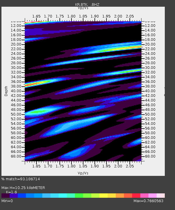
| Estimated Moho Depth: |
10.25 km |
| Estimated Crust Vp/Vs: |
1.60 |
| Assumed Crust Vp: |
6.236 km/s |
| Estimated Crust Vs: |
3.897 km/s |
| Estimated Crust Poisson's Ratio: |
0.18 |
|
| Radial Match: |
93.186714 % |
| Radial Bump: |
400 |
| Transverse Match: |
79.07265 % |
| Transverse Bump: |
400 |
| SOD ConfigId: |
626651 |
| Insert Time: |
2014-06-01 01:23:19.646 +0000 |
| GWidth: |
2.5 |
| Max Bumps: |
400 |
| Tol: |
0.001 |
|

Signal To Noise
| Channel | StoN | STA | LTA |
| KR:BTK: :BHZ:20140518T01:09:39.599985Z | 21.620714 | 9.228862E-7 | 4.2685276E-8 |
| KR:BTK: :BHN:20140518T01:09:39.599985Z | 6.5676427 | 3.5785723E-7 | 5.4487924E-8 |
| KR:BTK: :BHE:20140518T01:09:39.599985Z | 3.7397144 | 1.5700458E-7 | 4.198304E-8 |
| Arrivals |
| Ps | 1.1 SECOND |
| PpPs | 4.0 SECOND |
| PsPs/PpSs | 5.0 SECOND |


