You are here: Home > Network List > NI - North-East Italy Broadband Network Stations List
> Station CLUD Cludinico > Earthquake Result Viewer
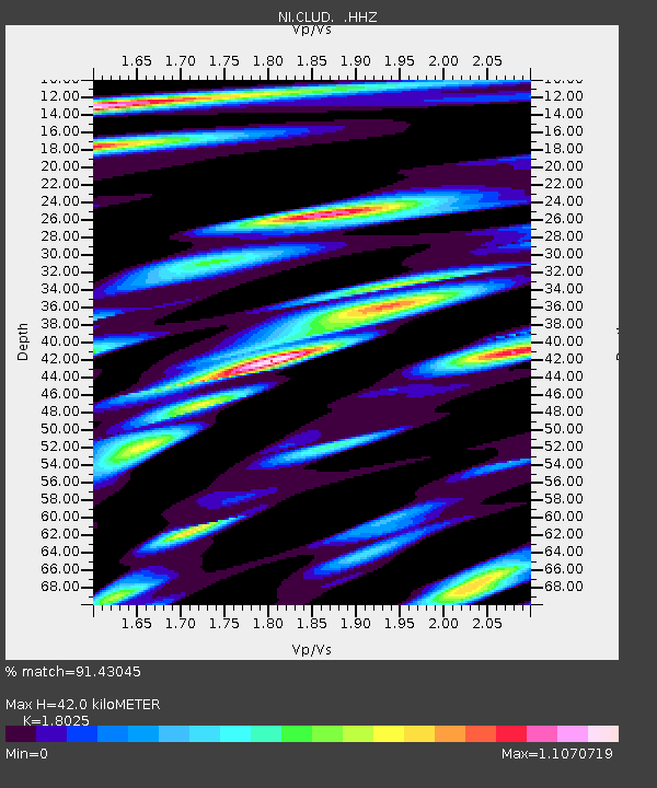
CLUD Cludinico - Earthquake Result Viewer
| Earthquake location: |
Off W Coast Of Northern Sumatra |
| Earthquake latitude/longitude: |
4.3/92.7 |
| Earthquake time(UTC): |
2014/05/18 (138) 01:02:29 GMT |
| Earthquake Depth: |
9.8 km |
| Earthquake Magnitude: |
6.2 MWP |
| Earthquake Catalog/Contributor: |
NEIC PDE/NEIC COMCAT |
|
| Network: |
NI North-East Italy Broadband Network |
| Station: |
CLUD Cludinico |
| Lat/Lon: |
46.46 N/12.88 E |
| Elevation: |
635 m |
|
| Distance: |
79.9 deg |
| Az: |
316.278 deg |
| Baz: |
94.414 deg |
| Ray Param: |
0.04861468 |
| Estimated Moho Depth: |
42.0 km |
| Estimated Crust Vp/Vs: |
1.80 |
| Assumed Crust Vp: |
6.35 km/s |
| Estimated Crust Vs: |
3.523 km/s |
| Estimated Crust Poisson's Ratio: |
0.28 |
|
| Radial Match: |
91.43045 % |
| Radial Bump: |
400 |
| Transverse Match: |
89.237465 % |
| Transverse Bump: |
400 |
| SOD ConfigId: |
626651 |
| Insert Time: |
2014-06-01 01:24:25.008 +0000 |
| GWidth: |
2.5 |
| Max Bumps: |
400 |
| Tol: |
0.001 |
|

Signal To Noise
| Channel | StoN | STA | LTA |
| NI:CLUD: :HHZ:20140518T01:14:06.977976Z | 20.086153 | 1.4086987E-6 | 7.013283E-8 |
| NI:CLUD: :HHN:20140518T01:14:06.977976Z | 9.945121 | 3.178141E-7 | 3.1956787E-8 |
| NI:CLUD: :HHE:20140518T01:14:06.977976Z | 15.163633 | 6.9884567E-7 | 4.6086953E-8 |
| Arrivals |
| Ps | 5.5 SECOND |
| PpPs | 18 SECOND |
| PsPs/PpSs | 23 SECOND |


