You are here: Home > Network List > NI - North-East Italy Broadband Network Stations List
> Station FUSE Fusea > Earthquake Result Viewer
FUSE Fusea - Earthquake Result Viewer
| Earthquake location: |
Off W Coast Of Northern Sumatra |
| Earthquake latitude/longitude: |
4.3/92.7 |
| Earthquake time(UTC): |
2014/05/18 (138) 01:02:29 GMT |
| Earthquake Depth: |
9.8 km |
| Earthquake Magnitude: |
6.2 MWP |
| Earthquake Catalog/Contributor: |
NEIC PDE/NEIC COMCAT |
|
| Network: |
NI North-East Italy Broadband Network |
| Station: |
FUSE Fusea |
| Lat/Lon: |
46.41 N/13.00 E |
| Elevation: |
574 m |
|
| Distance: |
79.9 deg |
| Az: |
316.241 deg |
| Baz: |
94.494 deg |
| Ray Param: |
0.04867335 |
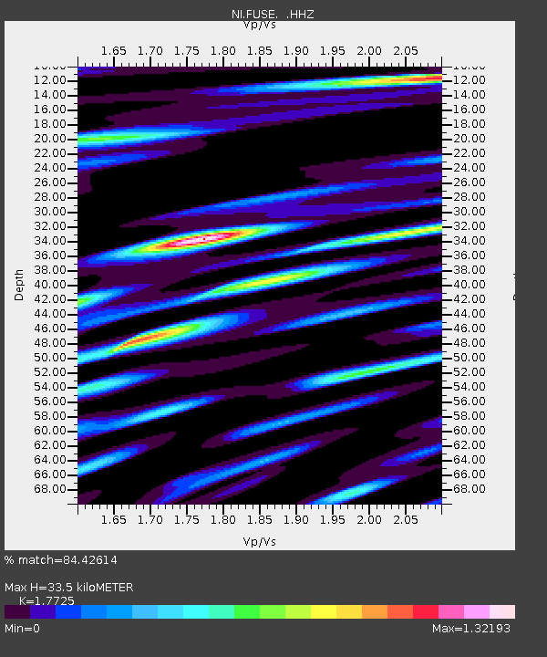
| Estimated Moho Depth: |
33.5 km |
| Estimated Crust Vp/Vs: |
1.77 |
| Assumed Crust Vp: |
6.35 km/s |
| Estimated Crust Vs: |
3.583 km/s |
| Estimated Crust Poisson's Ratio: |
0.27 |
|
| Radial Match: |
84.42614 % |
| Radial Bump: |
400 |
| Transverse Match: |
85.932526 % |
| Transverse Bump: |
400 |
| SOD ConfigId: |
626651 |
| Insert Time: |
2014-06-01 01:24:32.944 +0000 |
| GWidth: |
2.5 |
| Max Bumps: |
400 |
| Tol: |
0.001 |
|

Signal To Noise
| Channel | StoN | STA | LTA |
| NI:FUSE: :HHZ:20140518T01:14:06.518015Z | 20.183523 | 1.1637007E-6 | 5.7655978E-8 |
| NI:FUSE: :HHN:20140518T01:14:06.518015Z | 3.8898218 | 3.3707724E-7 | 8.665622E-8 |
| NI:FUSE: :HHE:20140518T01:14:06.518015Z | 7.4497504 | 5.059692E-7 | 6.7917604E-8 |
| Arrivals |
| Ps | 4.2 SECOND |
| PpPs | 14 SECOND |
| PsPs/PpSs | 18 SECOND |


