You are here: Home > Network List > NI - North-East Italy Broadband Network Stations List
> Station PRED Cave del Predil > Earthquake Result Viewer
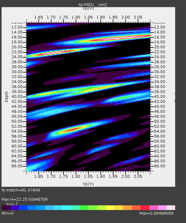
PRED Cave del Predil - Earthquake Result Viewer
| Earthquake location: |
Off W Coast Of Northern Sumatra |
| Earthquake latitude/longitude: |
4.3/92.7 |
| Earthquake time(UTC): |
2014/05/18 (138) 01:02:29 GMT |
| Earthquake Depth: |
9.8 km |
| Earthquake Magnitude: |
6.2 MWP |
| Earthquake Catalog/Contributor: |
NEIC PDE/NEIC COMCAT |
|
| Network: |
NI North-East Italy Broadband Network |
| Station: |
PRED Cave del Predil |
| Lat/Lon: |
46.44 N/13.56 E |
| Elevation: |
879 m |
|
| Distance: |
79.5 deg |
| Az: |
316.303 deg |
| Baz: |
94.912 deg |
| Ray Param: |
0.048938144 |
| Estimated Moho Depth: |
22.25 km |
| Estimated Crust Vp/Vs: |
1.70 |
| Assumed Crust Vp: |
6.35 km/s |
| Estimated Crust Vs: |
3.735 km/s |
| Estimated Crust Poisson's Ratio: |
0.24 |
|
| Radial Match: |
81.47646 % |
| Radial Bump: |
400 |
| Transverse Match: |
82.227005 % |
| Transverse Bump: |
400 |
| SOD ConfigId: |
626651 |
| Insert Time: |
2014-06-01 01:24:39.721 +0000 |
| GWidth: |
2.5 |
| Max Bumps: |
400 |
| Tol: |
0.001 |
|

Signal To Noise
| Channel | StoN | STA | LTA |
| NI:PRED: :HHZ:20140518T01:14:04.427988Z | 21.037624 | 1.0493559E-6 | 4.987996E-8 |
| NI:PRED: :HHN:20140518T01:14:04.427988Z | 3.614471 | 2.5048593E-7 | 6.930086E-8 |
| NI:PRED: :HHE:20140518T01:14:04.427988Z | 6.493302 | 3.420588E-7 | 5.267872E-8 |
| Arrivals |
| Ps | 2.5 SECOND |
| PpPs | 9.2 SECOND |
| PsPs/PpSs | 12 SECOND |


