You are here: Home > Network List > NI - North-East Italy Broadband Network Stations List
> Station ZOU2 Zouf Plan > Earthquake Result Viewer
ZOU2 Zouf Plan - Earthquake Result Viewer
| Earthquake location: |
Off W Coast Of Northern Sumatra |
| Earthquake latitude/longitude: |
4.3/92.7 |
| Earthquake time(UTC): |
2014/05/18 (138) 01:02:29 GMT |
| Earthquake Depth: |
9.8 km |
| Earthquake Magnitude: |
6.2 MWP |
| Earthquake Catalog/Contributor: |
NEIC PDE/NEIC COMCAT |
|
| Network: |
NI North-East Italy Broadband Network |
| Station: |
ZOU2 Zouf Plan |
| Lat/Lon: |
46.56 N/12.97 E |
| Elevation: |
1896 m |
|
| Distance: |
79.9 deg |
| Az: |
316.385 deg |
| Baz: |
94.5 deg |
| Ray Param: |
0.048652798 |
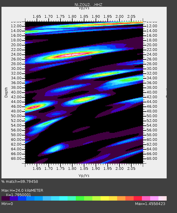
| Estimated Moho Depth: |
24.0 km |
| Estimated Crust Vp/Vs: |
1.80 |
| Assumed Crust Vp: |
6.35 km/s |
| Estimated Crust Vs: |
3.538 km/s |
| Estimated Crust Poisson's Ratio: |
0.27 |
|
| Radial Match: |
89.79458 % |
| Radial Bump: |
400 |
| Transverse Match: |
74.429825 % |
| Transverse Bump: |
400 |
| SOD ConfigId: |
626651 |
| Insert Time: |
2014-06-01 01:24:47.319 +0000 |
| GWidth: |
2.5 |
| Max Bumps: |
400 |
| Tol: |
0.001 |
|

Signal To Noise
| Channel | StoN | STA | LTA |
| NI:ZOU2: :HHZ:20140518T01:14:06.687998Z | 17.332087 | 1.7528541E-6 | 1.0113347E-7 |
| NI:ZOU2: :HHN:20140518T01:14:06.687998Z | 3.3493423 | 2.7868492E-7 | 8.320587E-8 |
| NI:ZOU2: :HHE:20140518T01:14:06.687998Z | 10.778295 | 6.733498E-7 | 6.247276E-8 |
| Arrivals |
| Ps | 3.1 SECOND |
| PpPs | 10 SECOND |
| PsPs/PpSs | 13 SECOND |


