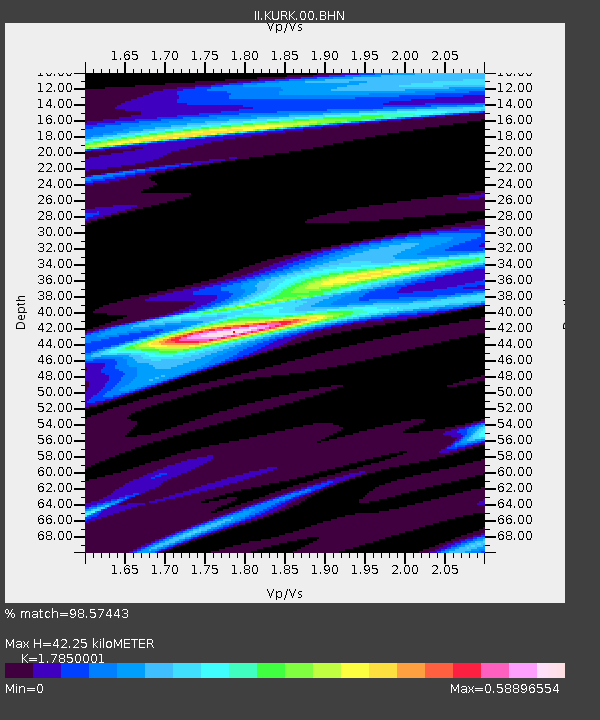
KURK Kurchatov, Kazakhstan - Earthquake Result Viewer
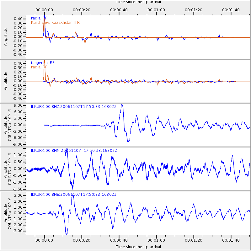
Earthquake location: New Britain Region, P.N.G.
Earthquake latitude/longitude: -6.5/151.2
Earthquake time(UTC): 2006/11/07 (311) 17:38:33 GMT
Earthquake Depth: 10 km
Earthquake Magnitude: 6.2 MB, 6.3 MS, 6.5 MW, 6.4 MW
Earthquake Catalog/Contributor: WHDF/NEIC
Network: II Global Seismograph Network (GSN - IRIS/IDA)
Station: KURK Kurchatov, Kazakhstan
Lat/Lon: 50.72 N/78.62 E
Elevation: 184 m
Distance: 84.1 deg
Az: 322.428 deg
Baz: 107.613 deg
Ray Param: 0.0457119
Estimated Moho Depth: 42.25 km
Estimated Crust Vp/Vs: 1.79
Assumed Crust Vp: 6.552 km/s
Estimated Crust Vs: 3.671 km/s
Estimated Crust Poisson's Ratio: 0.27
Radial Match: 98.57443 %
Radial Bump: 287
Transverse Match: 86.58875 %
Transverse Bump: 400
SOD ConfigId: 2564
Insert Time: 2010-03-01 22:24:21.172 +0000
GWidth: 2.5
Max Bumps: 400
Tol: 0.001

Signal To Noise

ChannelStoNSTALTA
II:KURK:00:BHN:20061107T17:50:33.16302Z0.805674141.0714106E-71.3298313E-7
II:KURK:00:BHE:20061107T17:50:33.16302Z1.79353881.3719115E-77.649188E-8
II:KURK:00:BHZ:20061107T17:50:33.16302Z3.33713534.2891764E-71.285287E-7
Arrivals
Ps5.2 SECOND
PpPs17 SECOND
PsPs/PpSs23 SECOND