You are here: Home > Network List > AU - Australian Seismological Centre Stations List
> Station TOO Toolangi, Victoria > Earthquake Result Viewer
TOO Toolangi, Victoria - Earthquake Result Viewer
| Earthquake location: |
Flores Sea |
| Earthquake latitude/longitude: |
-7.3/122.5 |
| Earthquake time(UTC): |
2015/02/27 (058) 13:45:05 GMT |
| Earthquake Depth: |
547 km |
| Earthquake Magnitude: |
6.6 MB |
| Earthquake Catalog/Contributor: |
NEIC PDE/NEIC ALERT |
|
| Network: |
AU Australian Seismological Centre |
| Station: |
TOO Toolangi, Victoria |
| Lat/Lon: |
37.57 S/145.49 E |
| Elevation: |
604 m |
|
| Distance: |
36.7 deg |
| Az: |
148.699 deg |
| Baz: |
319.56 deg |
| Ray Param: |
0.07385232 |
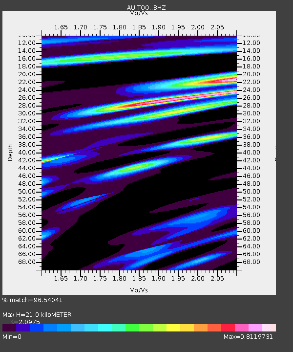
| Estimated Moho Depth: |
21.0 km |
| Estimated Crust Vp/Vs: |
2.10 |
| Assumed Crust Vp: |
6.577 km/s |
| Estimated Crust Vs: |
3.136 km/s |
| Estimated Crust Poisson's Ratio: |
0.35 |
|
| Radial Match: |
96.54041 % |
| Radial Bump: |
243 |
| Transverse Match: |
74.466805 % |
| Transverse Bump: |
400 |
| SOD ConfigId: |
7019011 |
| Insert Time: |
2019-04-17 03:03:23.182 +0000 |
| GWidth: |
2.5 |
| Max Bumps: |
400 |
| Tol: |
0.001 |
|

Signal To Noise
| Channel | StoN | STA | LTA |
| AU:TOO: :BHZ:20150227T13:50:54.569Z | 10.430486 | 3.244227E-6 | 3.1103318E-7 |
| AU:TOO: :BHN:20150227T13:50:54.569Z | 6.0158763 | 1.6579992E-6 | 2.7560392E-7 |
| AU:TOO: :BHE:20150227T13:50:54.569Z | 7.3901505 | 1.019345E-6 | 1.379329E-7 |
| Arrivals |
| Ps | 3.7 SECOND |
| PpPs | 9.3 SECOND |
| PsPs/PpSs | 13 SECOND |


