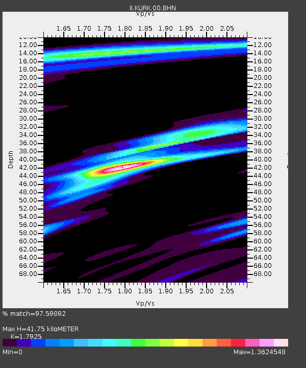
KURK Kurchatov, Kazakhstan - Earthquake Result Viewer
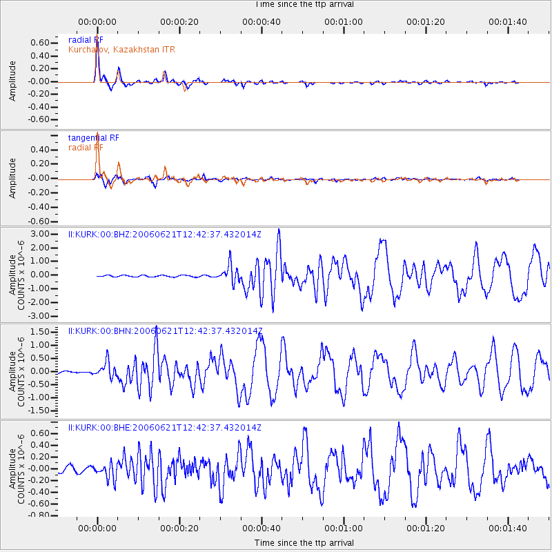
Earthquake location: Nicobar Islands, India Region
Earthquake latitude/longitude: 6.9/92.5
Earthquake time(UTC): 2006/06/21 (172) 12:34:52 GMT
Earthquake Depth: 16 km
Earthquake Magnitude: 5.7 MB, 5.7 MS, 5.9 MW, 5.9 MW
Earthquake Catalog/Contributor: WHDF/NEIC
Network: II Global Seismograph Network (GSN - IRIS/IDA)
Station: KURK Kurchatov, Kazakhstan
Lat/Lon: 50.72 N/78.62 E
Elevation: 184 m
Distance: 45.1 deg
Az: 347.616 deg
Baz: 160.432 deg
Ray Param: 0.07146232
Estimated Moho Depth: 41.75 km
Estimated Crust Vp/Vs: 1.79
Assumed Crust Vp: 6.552 km/s
Estimated Crust Vs: 3.655 km/s
Estimated Crust Poisson's Ratio: 0.27
Radial Match: 97.59892 %
Radial Bump: 238
Transverse Match: 90.01193 %
Transverse Bump: 400
SOD ConfigId: 5423
Insert Time: 2010-03-01 22:25:07.612 +0000
GWidth: 2.5
Max Bumps: 400
Tol: 0.001

Signal To Noise

ChannelStoNSTALTA
II:KURK:00:BHN:20060621T12:42:37.432014Z7.60632133.0738548E-74.0411845E-8
II:KURK:00:BHE:20060621T12:42:37.432014Z2.98912241.301634E-74.3545693E-8
II:KURK:00:BHZ:20060621T12:42:37.432014Z11.1551926.3977893E-75.735257E-8
Arrivals
Ps5.4 SECOND
PpPs17 SECOND
PsPs/PpSs22 SECOND