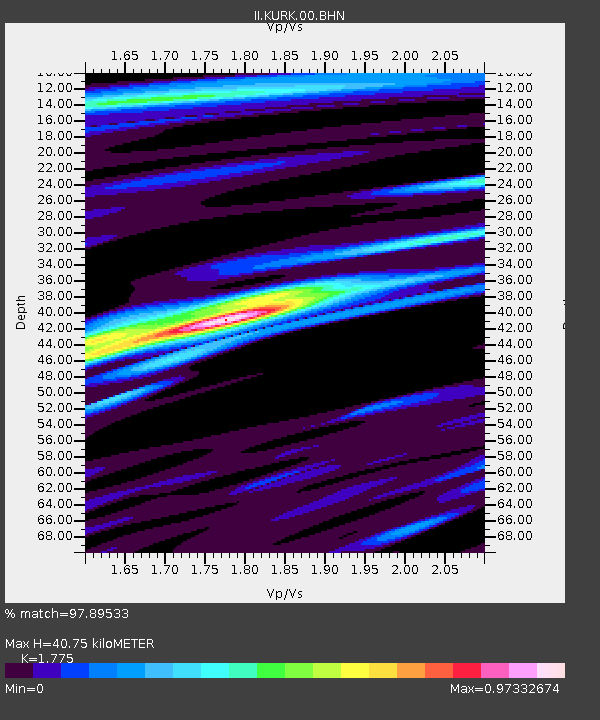
KURK Kurchatov, Kazakhstan - Earthquake Result Viewer
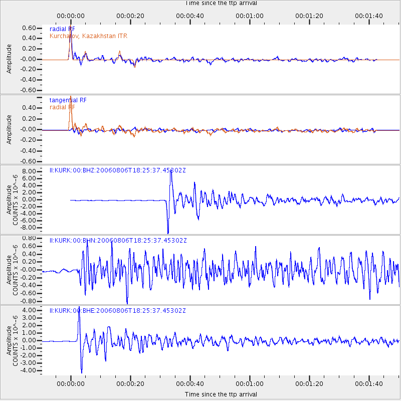
Earthquake location: Bonin Islands, Japan Region
Earthquake latitude/longitude: 26.1/144.0
Earthquake time(UTC): 2006/08/06 (218) 18:16:40 GMT
Earthquake Depth: 23 km
Earthquake Magnitude: 6.0 MB, 5.6 MS, 5.8 MW, 5.8 MW
Earthquake Catalog/Contributor: WHDF/NEIC
Network: II Global Seismograph Network (GSN - IRIS/IDA)
Station: KURK Kurchatov, Kazakhstan
Lat/Lon: 50.72 N/78.62 E
Elevation: 184 m
Distance: 54.8 deg
Az: 315.005 deg
Baz: 90.747 deg
Ray Param: 0.06516555
Estimated Moho Depth: 40.75 km
Estimated Crust Vp/Vs: 1.77
Assumed Crust Vp: 6.552 km/s
Estimated Crust Vs: 3.692 km/s
Estimated Crust Poisson's Ratio: 0.27
Radial Match: 97.89533 %
Radial Bump: 379
Transverse Match: 88.638405 %
Transverse Bump: 400
SOD ConfigId: 2665
Insert Time: 2010-03-01 22:25:19.002 +0000
GWidth: 2.5
Max Bumps: 400
Tol: 0.001

Signal To Noise

ChannelStoNSTALTA
II:KURK:00:BHN:20060806T18:25:37.45302Z8.2604642.0770061E-72.514394E-8
II:KURK:00:BHE:20060806T18:25:37.45302Z77.5302051.7631728E-62.2741752E-8
II:KURK:00:BHZ:20060806T18:25:37.45302Z78.3863143.871167E-64.9385754E-8
Arrivals
Ps5.1 SECOND
PpPs16 SECOND
PsPs/PpSs21 SECOND