You are here: Home > Network List > JP - Japan Meteorological Agency Seismic Network Stations List
> Station YOJ Yonagunijima Island > Earthquake Result Viewer
YOJ Yonagunijima Island - Earthquake Result Viewer
| Earthquake location: |
Flores Sea |
| Earthquake latitude/longitude: |
-7.3/122.5 |
| Earthquake time(UTC): |
2015/02/27 (058) 13:45:05 GMT |
| Earthquake Depth: |
547 km |
| Earthquake Magnitude: |
6.6 MB |
| Earthquake Catalog/Contributor: |
NEIC PDE/NEIC ALERT |
|
| Network: |
JP Japan Meteorological Agency Seismic Network |
| Station: |
YOJ Yonagunijima Island |
| Lat/Lon: |
24.47 N/123.01 E |
| Elevation: |
32 m |
|
| Distance: |
31.6 deg |
| Az: |
0.875 deg |
| Baz: |
180.953 deg |
| Ray Param: |
0.07659216 |
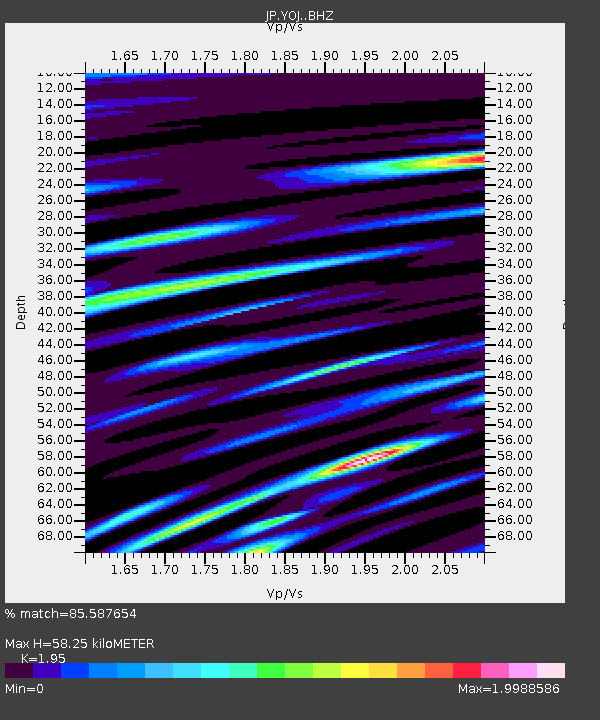
| Estimated Moho Depth: |
58.25 km |
| Estimated Crust Vp/Vs: |
1.95 |
| Assumed Crust Vp: |
6.183 km/s |
| Estimated Crust Vs: |
3.171 km/s |
| Estimated Crust Poisson's Ratio: |
0.32 |
|
| Radial Match: |
85.587654 % |
| Radial Bump: |
400 |
| Transverse Match: |
76.69598 % |
| Transverse Bump: |
400 |
| SOD ConfigId: |
7019011 |
| Insert Time: |
2019-04-17 03:04:48.973 +0000 |
| GWidth: |
2.5 |
| Max Bumps: |
400 |
| Tol: |
0.001 |
|

Signal To Noise
| Channel | StoN | STA | LTA |
| JP:YOJ: :BHZ:20150227T13:50:13.049988Z | 40.71908 | 4.7606703E-5 | 1.1691498E-6 |
| JP:YOJ: :BHN:20150227T13:50:13.049988Z | 7.997094 | 1.5161078E-5 | 1.8958234E-6 |
| JP:YOJ: :BHE:20150227T13:50:13.049988Z | 1.9652997 | 3.2937137E-6 | 1.6759346E-6 |
| Arrivals |
| Ps | 9.5 SECOND |
| PpPs | 26 SECOND |
| PsPs/PpSs | 36 SECOND |


