You are here: Home > Network List > S - Seismographs in Schools Projects Stations List
> Station AUBSH Beerwah State High School, QLD > Earthquake Result Viewer
AUBSH Beerwah State High School, QLD - Earthquake Result Viewer
| Earthquake location: |
Flores Sea |
| Earthquake latitude/longitude: |
-7.3/122.5 |
| Earthquake time(UTC): |
2015/02/27 (058) 13:45:05 GMT |
| Earthquake Depth: |
547 km |
| Earthquake Magnitude: |
6.6 MB |
| Earthquake Catalog/Contributor: |
NEIC PDE/NEIC ALERT |
|
| Network: |
S Seismographs in Schools Projects |
| Station: |
AUBSH Beerwah State High School, QLD |
| Lat/Lon: |
26.86 S/152.95 E |
| Elevation: |
26 m |
|
| Distance: |
34.9 deg |
| Az: |
127.625 deg |
| Baz: |
298.409 deg |
| Ray Param: |
0.074855596 |
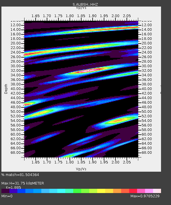
| Estimated Moho Depth: |
31.75 km |
| Estimated Crust Vp/Vs: |
1.88 |
| Assumed Crust Vp: |
6.472 km/s |
| Estimated Crust Vs: |
3.433 km/s |
| Estimated Crust Poisson's Ratio: |
0.30 |
|
| Radial Match: |
81.504364 % |
| Radial Bump: |
400 |
| Transverse Match: |
65.1252 % |
| Transverse Bump: |
400 |
| SOD ConfigId: |
7019011 |
| Insert Time: |
2019-04-17 03:05:28.005 +0000 |
| GWidth: |
2.5 |
| Max Bumps: |
400 |
| Tol: |
0.001 |
|

Signal To Noise
| Channel | StoN | STA | LTA |
| S:AUBSH: :HHZ:20150227T13:50:39.829987Z | 34.945694 | 8.375388E-6 | 2.3966865E-7 |
| S:AUBSH: :HHN:20150227T13:50:39.829987Z | 4.7837524 | 1.6144629E-6 | 3.374888E-7 |
| S:AUBSH: :HHE:20150227T13:50:39.829987Z | 20.468336 | 5.1867532E-6 | 2.5340375E-7 |
| Arrivals |
| Ps | 4.6 SECOND |
| PpPs | 13 SECOND |
| PsPs/PpSs | 18 SECOND |


