You are here: Home > Network List > S - Seismographs in Schools Projects Stations List
> Station AUMTS Mt Stromlo, ANU > Earthquake Result Viewer
AUMTS Mt Stromlo, ANU - Earthquake Result Viewer
| Earthquake location: |
Flores Sea |
| Earthquake latitude/longitude: |
-7.3/122.5 |
| Earthquake time(UTC): |
2015/02/27 (058) 13:45:05 GMT |
| Earthquake Depth: |
547 km |
| Earthquake Magnitude: |
6.6 MB |
| Earthquake Catalog/Contributor: |
NEIC PDE/NEIC ALERT |
|
| Network: |
S Seismographs in Schools Projects |
| Station: |
AUMTS Mt Stromlo, ANU |
| Lat/Lon: |
35.32 S/149.00 E |
| Elevation: |
667 m |
|
| Distance: |
37.0 deg |
| Az: |
142.701 deg |
| Baz: |
312.683 deg |
| Ray Param: |
0.07365393 |
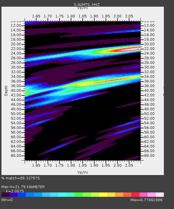
| Estimated Moho Depth: |
21.75 km |
| Estimated Crust Vp/Vs: |
2.09 |
| Assumed Crust Vp: |
6.633 km/s |
| Estimated Crust Vs: |
3.178 km/s |
| Estimated Crust Poisson's Ratio: |
0.35 |
|
| Radial Match: |
89.337975 % |
| Radial Bump: |
400 |
| Transverse Match: |
70.15286 % |
| Transverse Bump: |
400 |
| SOD ConfigId: |
7019011 |
| Insert Time: |
2019-04-17 03:05:35.874 +0000 |
| GWidth: |
2.5 |
| Max Bumps: |
400 |
| Tol: |
0.001 |
|

Signal To Noise
| Channel | StoN | STA | LTA |
| S:AUMTS: :HHZ:20150227T13:50:57.399994Z | 16.188385 | 7.2335E-6 | 4.468327E-7 |
| S:AUMTS: :HHN:20150227T13:50:57.399994Z | 10.76052 | 3.4265547E-6 | 3.1843766E-7 |
| S:AUMTS: :HHE:20150227T13:50:57.399994Z | 6.961008 | 2.6041992E-6 | 3.7411237E-7 |
| Arrivals |
| Ps | 3.8 SECOND |
| PpPs | 9.5 SECOND |
| PsPs/PpSs | 13 SECOND |


