You are here: Home > Network List > XL12 - Hangay Dome, Mongolia Stations List
> Station HV21 HV21 > Earthquake Result Viewer
HV21 HV21 - Earthquake Result Viewer
| Earthquake location: |
Flores Sea |
| Earthquake latitude/longitude: |
-7.3/122.5 |
| Earthquake time(UTC): |
2015/02/27 (058) 13:45:05 GMT |
| Earthquake Depth: |
547 km |
| Earthquake Magnitude: |
6.6 MB |
| Earthquake Catalog/Contributor: |
NEIC PDE/NEIC ALERT |
|
| Network: |
XL Hangay Dome, Mongolia |
| Station: |
HV21 HV21 |
| Lat/Lon: |
51.43 N/100.78 E |
| Elevation: |
1677 m |
|
| Distance: |
61.4 deg |
| Az: |
344.692 deg |
| Baz: |
155.271 deg |
| Ray Param: |
0.05881217 |
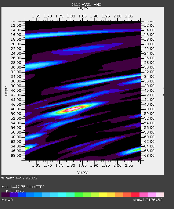
| Estimated Moho Depth: |
47.75 km |
| Estimated Crust Vp/Vs: |
1.81 |
| Assumed Crust Vp: |
6.419 km/s |
| Estimated Crust Vs: |
3.551 km/s |
| Estimated Crust Poisson's Ratio: |
0.28 |
|
| Radial Match: |
92.92872 % |
| Radial Bump: |
400 |
| Transverse Match: |
75.42275 % |
| Transverse Bump: |
400 |
| SOD ConfigId: |
7019011 |
| Insert Time: |
2019-04-17 03:06:17.126 +0000 |
| GWidth: |
2.5 |
| Max Bumps: |
400 |
| Tol: |
0.001 |
|

Signal To Noise
| Channel | StoN | STA | LTA |
| XL:HV21: :HHZ:20150227T13:53:57.460022Z | 55.301712 | 7.453596E-6 | 1.3478056E-7 |
| XL:HV21: :HHN:20150227T13:53:57.460022Z | 17.893816 | 2.9425423E-6 | 1.6444466E-7 |
| XL:HV21: :HHE:20150227T13:53:57.460022Z | 21.628109 | 1.8385047E-6 | 8.500534E-8 |
| Arrivals |
| Ps | 6.3 SECOND |
| PpPs | 20 SECOND |
| PsPs/PpSs | 26 SECOND |


