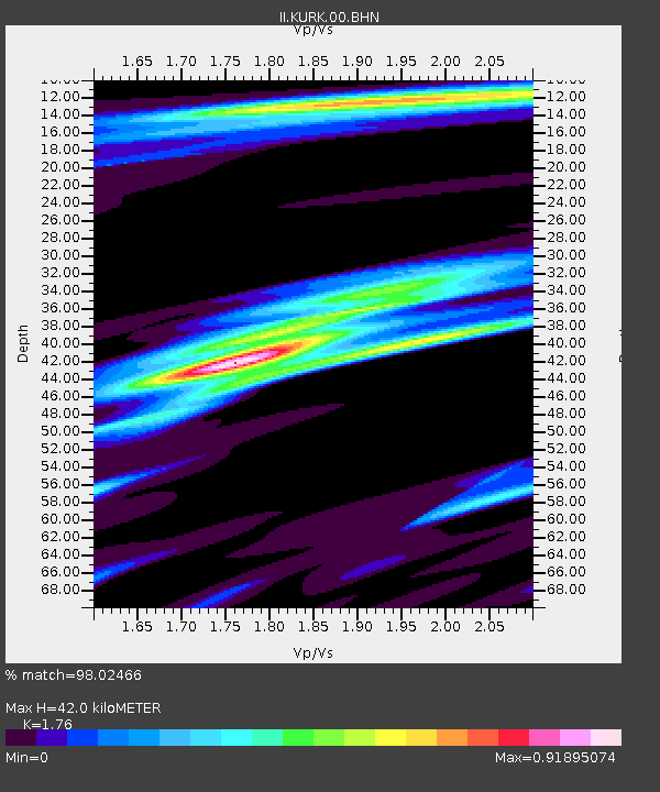
KURK Kurchatov, Kazakhstan - Earthquake Result Viewer

Earthquake location: Northern Sumatra, Indonesia
Earthquake latitude/longitude: 0.1/97.1
Earthquake time(UTC): 2006/05/16 (136) 15:28:25 GMT
Earthquake Depth: 12 km
Earthquake Magnitude: 6.6 MB, 6.8 MS, 6.8 MW, 6.8 MW
Earthquake Catalog/Contributor: WHDF/NEIC
Network: II Global Seismograph Network (GSN - IRIS/IDA)
Station: KURK Kurchatov, Kazakhstan
Lat/Lon: 50.72 N/78.62 E
Elevation: 184 m
Distance: 52.8 deg
Az: 345.389 deg
Baz: 156.621 deg
Ray Param: 0.066511124
Estimated Moho Depth: 42.0 km
Estimated Crust Vp/Vs: 1.76
Assumed Crust Vp: 6.552 km/s
Estimated Crust Vs: 3.723 km/s
Estimated Crust Poisson's Ratio: 0.26
Radial Match: 98.02466 %
Radial Bump: 393
Transverse Match: 90.99311 %
Transverse Bump: 400
SOD ConfigId: 2669
Insert Time: 2010-03-01 22:26:32.299 +0000
GWidth: 2.5
Max Bumps: 400
Tol: 0.001

Signal To Noise

ChannelStoNSTALTA
II:KURK:00:BHN:20060516T15:37:10.052019Z23.535511.9317476E-68.2078E-8
II:KURK:00:BHE:20060516T15:37:10.052019Z5.45869736.530011E-71.1962581E-7
II:KURK:00:BHZ:20060516T15:37:10.052019Z55.7216764.788775E-68.5940975E-8
Arrivals
Ps5.2 SECOND
PpPs17 SECOND
PsPs/PpSs22 SECOND