You are here: Home > Network List > YQ13 - Study of Extension and Magmatism in Malawi and Tanzania Stations List
> Station ENUK Enukweni,Malawi > Earthquake Result Viewer
ENUK Enukweni,Malawi - Earthquake Result Viewer
| Earthquake location: |
Flores Sea |
| Earthquake latitude/longitude: |
-7.3/122.5 |
| Earthquake time(UTC): |
2015/02/27 (058) 13:45:05 GMT |
| Earthquake Depth: |
547 km |
| Earthquake Magnitude: |
6.6 MB |
| Earthquake Catalog/Contributor: |
NEIC PDE/NEIC ALERT |
|
| Network: |
YQ Study of Extension and Magmatism in Malawi and Tanzania |
| Station: |
ENUK Enukweni,Malawi |
| Lat/Lon: |
11.18 S/33.89 E |
| Elevation: |
3619 m |
|
| Distance: |
87.3 deg |
| Az: |
259.143 deg |
| Baz: |
96.841 deg |
| Ray Param: |
0.041914616 |
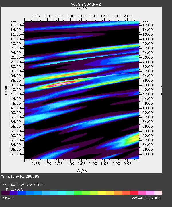
| Estimated Moho Depth: |
37.25 km |
| Estimated Crust Vp/Vs: |
1.76 |
| Assumed Crust Vp: |
6.367 km/s |
| Estimated Crust Vs: |
3.623 km/s |
| Estimated Crust Poisson's Ratio: |
0.26 |
|
| Radial Match: |
91.299965 % |
| Radial Bump: |
263 |
| Transverse Match: |
72.89103 % |
| Transverse Bump: |
400 |
| SOD ConfigId: |
7019011 |
| Insert Time: |
2019-04-17 03:07:09.721 +0000 |
| GWidth: |
2.5 |
| Max Bumps: |
400 |
| Tol: |
0.001 |
|

Signal To Noise
| Channel | StoN | STA | LTA |
| YQ:ENUK: :HHZ:20150227T13:56:21.750Z | 10.41592 | 1.856191E-6 | 1.782071E-7 |
| YQ:ENUK: :HHN:20150227T13:56:21.750Z | 0.8994801 | 1.7213952E-7 | 1.913767E-7 |
| YQ:ENUK: :HHE:20150227T13:56:21.750Z | 4.675861 | 6.695076E-7 | 1.4318381E-7 |
| Arrivals |
| Ps | 4.5 SECOND |
| PpPs | 16 SECOND |
| PsPs/PpSs | 20 SECOND |


