You are here: Home > Network List > YQ13 - Study of Extension and Magmatism in Malawi and Tanzania Stations List
> Station GAWA Igawa,Tanzania > Earthquake Result Viewer
GAWA Igawa,Tanzania - Earthquake Result Viewer
| Earthquake location: |
Flores Sea |
| Earthquake latitude/longitude: |
-7.3/122.5 |
| Earthquake time(UTC): |
2015/02/27 (058) 13:45:05 GMT |
| Earthquake Depth: |
547 km |
| Earthquake Magnitude: |
6.6 MB |
| Earthquake Catalog/Contributor: |
NEIC PDE/NEIC ALERT |
|
| Network: |
YQ Study of Extension and Magmatism in Malawi and Tanzania |
| Station: |
GAWA Igawa,Tanzania |
| Lat/Lon: |
8.76 S/34.39 E |
| Elevation: |
1127 m |
|
| Distance: |
87.1 deg |
| Az: |
261.588 deg |
| Baz: |
96.875 deg |
| Ray Param: |
0.04205656 |
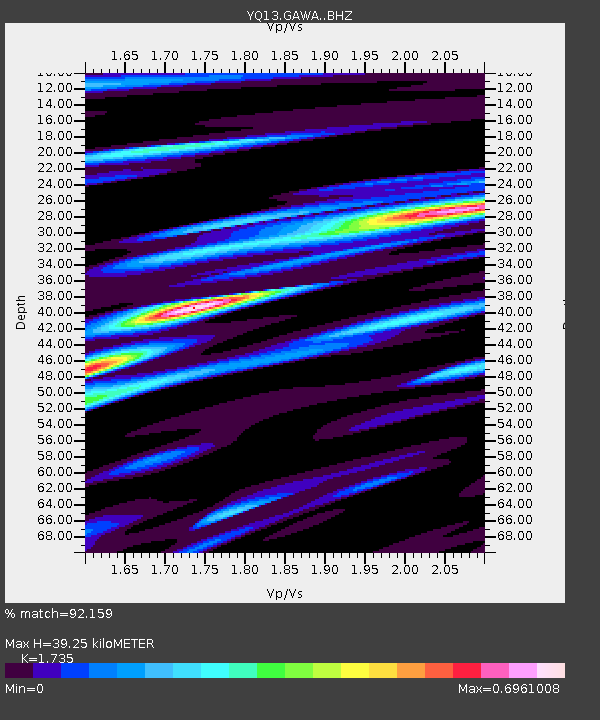
| Estimated Moho Depth: |
39.25 km |
| Estimated Crust Vp/Vs: |
1.74 |
| Assumed Crust Vp: |
6.576 km/s |
| Estimated Crust Vs: |
3.79 km/s |
| Estimated Crust Poisson's Ratio: |
0.25 |
|
| Radial Match: |
92.159 % |
| Radial Bump: |
373 |
| Transverse Match: |
78.074356 % |
| Transverse Bump: |
400 |
| SOD ConfigId: |
7019011 |
| Insert Time: |
2019-04-17 03:07:10.890 +0000 |
| GWidth: |
2.5 |
| Max Bumps: |
400 |
| Tol: |
0.001 |
|

Signal To Noise
| Channel | StoN | STA | LTA |
| YQ:GAWA: :BHZ:20150227T13:56:20.825012Z | 6.4057956 | 1.393745E-6 | 2.1757563E-7 |
| YQ:GAWA: :BHN:20150227T13:56:20.825012Z | 2.3962924 | 1.2666511E-7 | 5.2858788E-8 |
| YQ:GAWA: :BHE:20150227T13:56:20.825012Z | 5.5941257 | 5.322947E-7 | 9.515244E-8 |
| Arrivals |
| Ps | 4.5 SECOND |
| PpPs | 16 SECOND |
| PsPs/PpSs | 20 SECOND |


