You are here: Home > Network List > GT - Global Telemetered Seismograph Network (USAF/USGS) Stations List
> Station LPAZ La Paz , Bolivia > Earthquake Result Viewer
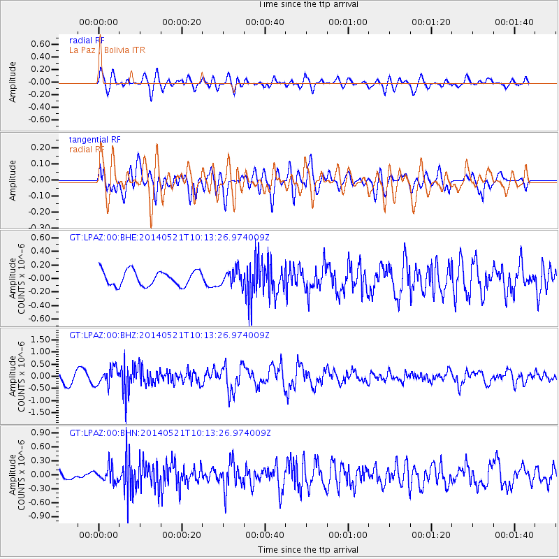
LPAZ La Paz , Bolivia - Earthquake Result Viewer
*The percent match for this event was below the threshold and hence no stack was calculated.
| Earthquake location: |
Chiapas, Mexico |
| Earthquake latitude/longitude: |
17.2/-94.9 |
| Earthquake time(UTC): |
2014/05/21 (141) 10:06:14 GMT |
| Earthquake Depth: |
128 km |
| Earthquake Magnitude: |
5.6 MWP |
| Earthquake Catalog/Contributor: |
NEIC PDE/NEIC COMCAT |
|
| Network: |
GT Global Telemetered Seismograph Network (USAF/USGS) |
| Station: |
LPAZ La Paz , Bolivia |
| Lat/Lon: |
16.17 S/68.08 W |
| Elevation: |
4817 m |
|
| Distance: |
42.4 deg |
| Az: |
139.97 deg |
| Baz: |
320.221 deg |
| Ray Param: |
$rayparam |
*The percent match for this event was below the threshold and hence was not used in the summary stack. |
|
| Radial Match: |
56.390007 % |
| Radial Bump: |
400 |
| Transverse Match: |
55.485332 % |
| Transverse Bump: |
400 |
| SOD ConfigId: |
626651 |
| Insert Time: |
2014-06-04 10:34:07.990 +0000 |
| GWidth: |
2.5 |
| Max Bumps: |
400 |
| Tol: |
0.001 |
|
Signal To Noise
| Channel | StoN | STA | LTA |
| GT:LPAZ:00:BHZ:20140521T10:13:26.974009Z | 1.7917256 | 3.4056313E-7 | 1.900755E-7 |
| GT:LPAZ:00:BHN:20140521T10:13:26.974009Z | 1.1227183 | 1.6072542E-7 | 1.431574E-7 |
| GT:LPAZ:00:BHE:20140521T10:13:26.974009Z | 0.9905944 | 1.086047E-7 | 1.096359E-7 |
| Arrivals |
| Ps | |
| PpPs | |
| PsPs/PpSs | |


