You are here: Home > Network List > YQ13 - Study of Extension and Magmatism in Malawi and Tanzania Stations List
> Station MAKE Makete,Tanzania > Earthquake Result Viewer
MAKE Makete,Tanzania - Earthquake Result Viewer
| Earthquake location: |
Flores Sea |
| Earthquake latitude/longitude: |
-7.3/122.5 |
| Earthquake time(UTC): |
2015/02/27 (058) 13:45:05 GMT |
| Earthquake Depth: |
547 km |
| Earthquake Magnitude: |
6.6 MB |
| Earthquake Catalog/Contributor: |
NEIC PDE/NEIC ALERT |
|
| Network: |
YQ Study of Extension and Magmatism in Malawi and Tanzania |
| Station: |
MAKE Makete,Tanzania |
| Lat/Lon: |
9.26 S/34.10 E |
| Elevation: |
2304 m |
|
| Distance: |
87.3 deg |
| Az: |
261.06 deg |
| Baz: |
96.894 deg |
| Ray Param: |
0.041899618 |
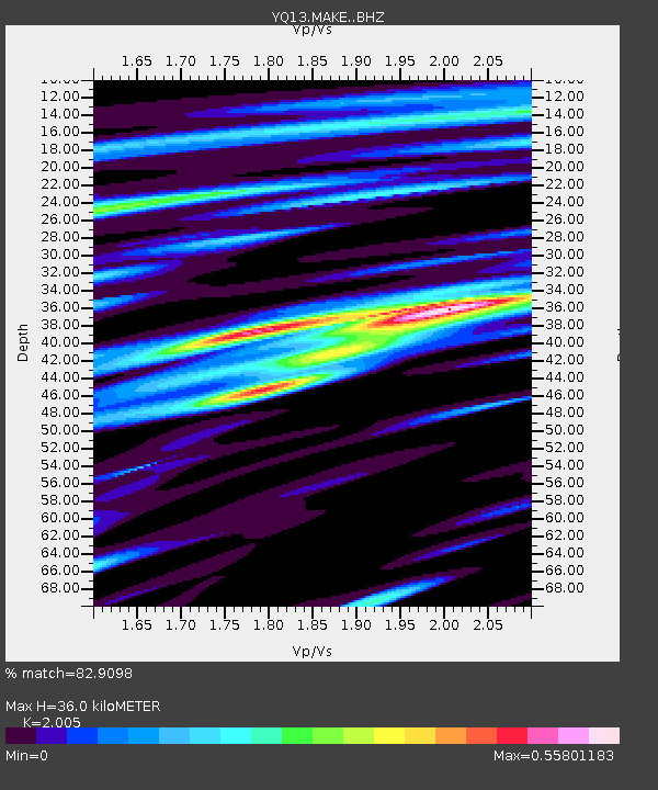
| Estimated Moho Depth: |
36.0 km |
| Estimated Crust Vp/Vs: |
2.01 |
| Assumed Crust Vp: |
6.576 km/s |
| Estimated Crust Vs: |
3.28 km/s |
| Estimated Crust Poisson's Ratio: |
0.33 |
|
| Radial Match: |
82.9098 % |
| Radial Bump: |
400 |
| Transverse Match: |
68.71662 % |
| Transverse Bump: |
400 |
| SOD ConfigId: |
7019011 |
| Insert Time: |
2019-04-17 03:07:20.594 +0000 |
| GWidth: |
2.5 |
| Max Bumps: |
400 |
| Tol: |
0.001 |
|

Signal To Noise
| Channel | StoN | STA | LTA |
| YQ:MAKE: :BHZ:20150227T13:56:21.875Z | 7.032378 | 1.3465655E-6 | 1.9148082E-7 |
| YQ:MAKE: :BHN:20150227T13:56:21.875Z | 0.8755635 | 3.3704953E-7 | 3.8495153E-7 |
| YQ:MAKE: :BHE:20150227T13:56:21.875Z | 1.8982159 | 7.0810216E-7 | 3.7303565E-7 |
| Arrivals |
| Ps | 5.6 SECOND |
| PpPs | 16 SECOND |
| PsPs/PpSs | 22 SECOND |


