You are here: Home > Network List > YQ13 - Study of Extension and Magmatism in Malawi and Tanzania Stations List
> Station ZINI Mgazini,Tanzania > Earthquake Result Viewer
ZINI Mgazini,Tanzania - Earthquake Result Viewer
| Earthquake location: |
Flores Sea |
| Earthquake latitude/longitude: |
-7.3/122.5 |
| Earthquake time(UTC): |
2015/02/27 (058) 13:45:05 GMT |
| Earthquake Depth: |
547 km |
| Earthquake Magnitude: |
6.6 MB |
| Earthquake Catalog/Contributor: |
NEIC PDE/NEIC ALERT |
|
| Network: |
YQ Study of Extension and Magmatism in Malawi and Tanzania |
| Station: |
ZINI Mgazini,Tanzania |
| Lat/Lon: |
10.47 S/35.34 E |
| Elevation: |
1044 m |
|
| Distance: |
85.9 deg |
| Az: |
260.017 deg |
| Baz: |
96.621 deg |
| Ray Param: |
0.04285929 |
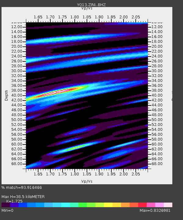
| Estimated Moho Depth: |
38.5 km |
| Estimated Crust Vp/Vs: |
1.73 |
| Assumed Crust Vp: |
6.502 km/s |
| Estimated Crust Vs: |
3.769 km/s |
| Estimated Crust Poisson's Ratio: |
0.25 |
|
| Radial Match: |
93.916466 % |
| Radial Bump: |
362 |
| Transverse Match: |
84.082 % |
| Transverse Bump: |
400 |
| SOD ConfigId: |
7019011 |
| Insert Time: |
2019-04-17 03:07:35.734 +0000 |
| GWidth: |
2.5 |
| Max Bumps: |
400 |
| Tol: |
0.001 |
|

Signal To Noise
| Channel | StoN | STA | LTA |
| YQ:ZINI: :BHZ:20150227T13:56:15.47998Z | 11.130407 | 1.9144381E-6 | 1.7200072E-7 |
| YQ:ZINI: :BHN:20150227T13:56:15.47998Z | 1.8165848 | 2.5680757E-7 | 1.4136833E-7 |
| YQ:ZINI: :BHE:20150227T13:56:15.47998Z | 5.098765 | 7.0104716E-7 | 1.3749352E-7 |
| Arrivals |
| Ps | 4.4 SECOND |
| PpPs | 16 SECOND |
| PsPs/PpSs | 20 SECOND |


