You are here: Home > Network List > II - Global Seismograph Network (GSN - IRIS/IDA) Stations List
> Station KURK Kurchatov, Kazakhstan > Earthquake Result Viewer
KURK Kurchatov, Kazakhstan - Earthquake Result Viewer
| Earthquake location: |
Eastern Siberia, Russia |
| Earthquake latitude/longitude: |
60.9/167.1 |
| Earthquake time(UTC): |
2006/04/20 (110) 23:25:02 GMT |
| Earthquake Depth: |
22 km |
| Earthquake Magnitude: |
6.8 MB, 7.6 MS, 7.6 MW, 7.3 MW |
| Earthquake Catalog/Contributor: |
WHDF/NEIC |
|
| Network: |
II Global Seismograph Network (GSN - IRIS/IDA) |
| Station: |
KURK Kurchatov, Kazakhstan |
| Lat/Lon: |
50.72 N/78.62 E |
| Elevation: |
184 m |
|
| Distance: |
47.0 deg |
| Az: |
299.663 deg |
| Baz: |
41.848 deg |
| Ray Param: |
0.07024973 |
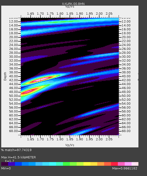
| Estimated Moho Depth: |
41.5 km |
| Estimated Crust Vp/Vs: |
1.70 |
| Assumed Crust Vp: |
6.552 km/s |
| Estimated Crust Vs: |
3.854 km/s |
| Estimated Crust Poisson's Ratio: |
0.24 |
|
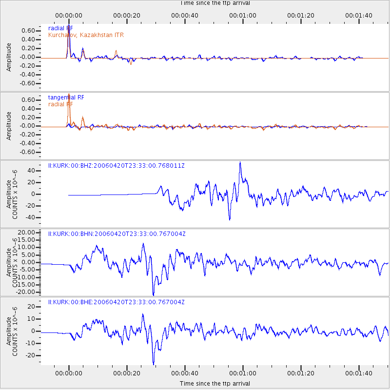
| Radial Match: |
97.74319 % |
| Radial Bump: |
267 |
| Transverse Match: |
87.59786 % |
| Transverse Bump: |
400 |
| SOD ConfigId: |
2669 |
| Insert Time: |
2010-03-01 22:27:08.943 +0000 |
| GWidth: |
2.5 |
| Max Bumps: |
400 |
| Tol: |
0.001 |
|
Signal To Noise
| Channel | StoN | STA | LTA |
| II:KURK:00:BHN:20060420T23:33:00.767004Z | 10.584755 | 3.029525E-6 | 2.862159E-7 |
| II:KURK:00:BHE:20060420T23:33:00.767004Z | 11.48837 | 3.2498835E-6 | 2.8288466E-7 |
| II:KURK:00:BHZ:20060420T23:33:00.768011Z | 11.785644 | 7.1634986E-6 | 6.0781565E-7 |
| Arrivals |
| Ps | 4.7 SECOND |
| PpPs | 16 SECOND |
| PsPs/PpSs | 21 SECOND |


