You are here: Home > Network List > YT07 - POLENET Stations List
> Station STEW STEW > Earthquake Result Viewer
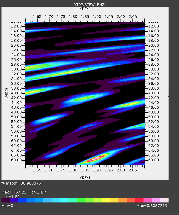
STEW STEW - Earthquake Result Viewer
| Earthquake location: |
Flores Sea |
| Earthquake latitude/longitude: |
-7.3/122.5 |
| Earthquake time(UTC): |
2015/02/27 (058) 13:45:05 GMT |
| Earthquake Depth: |
547 km |
| Earthquake Magnitude: |
6.6 MB |
| Earthquake Catalog/Contributor: |
NEIC PDE/NEIC ALERT |
|
| Network: |
YT POLENET |
| Station: |
STEW STEW |
| Lat/Lon: |
84.19 S/86.23 W |
| Elevation: |
1584 m |
|
| Distance: |
87.9 deg |
| Az: |
177.187 deg |
| Baz: |
208.514 deg |
| Ray Param: |
0.04170654 |
| Estimated Moho Depth: |
67.25 km |
| Estimated Crust Vp/Vs: |
1.89 |
| Assumed Crust Vp: |
6.338 km/s |
| Estimated Crust Vs: |
3.353 km/s |
| Estimated Crust Poisson's Ratio: |
0.31 |
|
| Radial Match: |
88.988075 % |
| Radial Bump: |
400 |
| Transverse Match: |
80.68851 % |
| Transverse Bump: |
400 |
| SOD ConfigId: |
7019011 |
| Insert Time: |
2019-04-17 03:08:02.592 +0000 |
| GWidth: |
2.5 |
| Max Bumps: |
400 |
| Tol: |
0.001 |
|

Signal To Noise
| Channel | StoN | STA | LTA |
| YT:STEW: :BHZ:20150227T13:56:24.500Z | 9.412721 | 1.7291898E-6 | 1.8370775E-7 |
| YT:STEW: :BHN:20150227T13:56:24.500Z | 4.755992 | 5.8480265E-7 | 1.2296124E-7 |
| YT:STEW: :BHE:20150227T13:56:24.500Z | 2.459343 | 4.320044E-7 | 1.7565847E-7 |
| Arrivals |
| Ps | 9.6 SECOND |
| PpPs | 30 SECOND |
| PsPs/PpSs | 40 SECOND |


