You are here: Home > Network List > TA - USArray Transportable Network (new EarthScope stations) Stations List
> Station D51A Lot 18 Range III Mazenod Township, QC, CAN > Earthquake Result Viewer
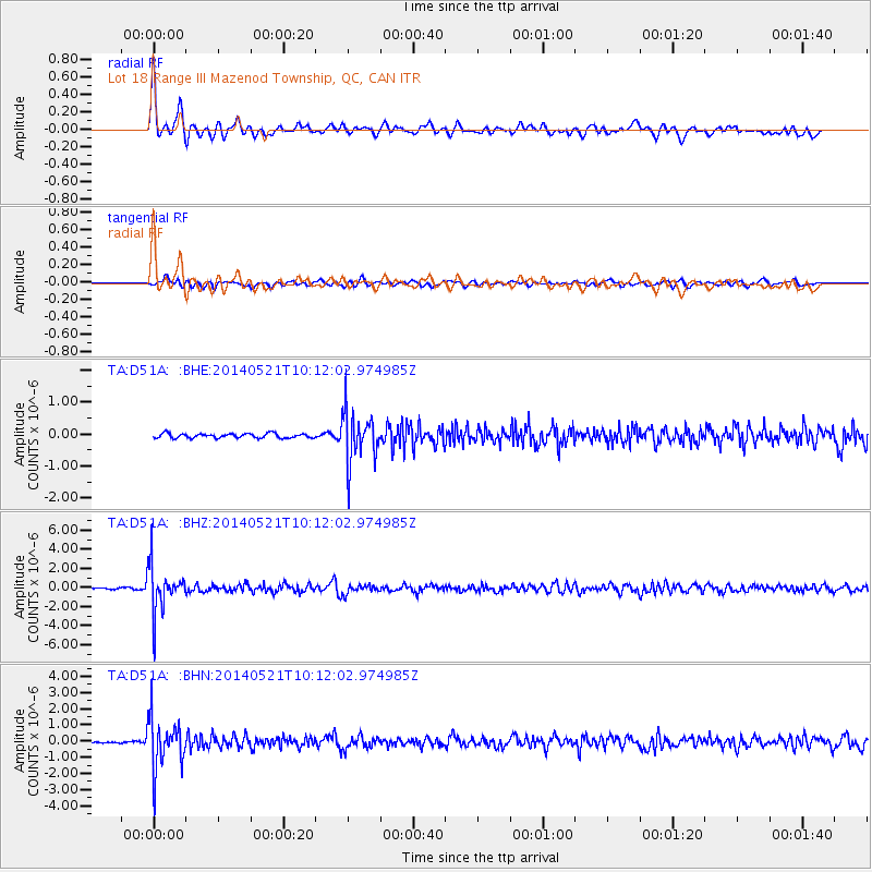
D51A Lot 18 Range III Mazenod Township, QC, CAN - Earthquake Result Viewer

| Earthquake location: |
Chiapas, Mexico |
| Earthquake latitude/longitude: |
17.2/-94.9 |
| Earthquake time(UTC): |
2014/05/21 (141) 10:06:14 GMT |
| Earthquake Depth: |
128 km |
| Earthquake Magnitude: |
5.6 MWP |
| Earthquake Catalog/Contributor: |
NEIC PDE/NEIC COMCAT |
|
| Network: |
TA USArray Transportable Network (new EarthScope stations) |
| Station: |
D51A Lot 18 Range III Mazenod Township, QC, CAN |
| Lat/Lon: |
47.09 N/79.37 W |
| Elevation: |
282 m |
|
| Distance: |
32.5 deg |
| Az: |
19.94 deg |
| Baz: |
208.496 deg |
| Ray Param: |
0.07827542 |
| Estimated Moho Depth: |
34.75 km |
| Estimated Crust Vp/Vs: |
1.74 |
| Assumed Crust Vp: |
6.622 km/s |
| Estimated Crust Vs: |
3.817 km/s |
| Estimated Crust Poisson's Ratio: |
0.25 |
|
| Radial Match: |
90.62114 % |
| Radial Bump: |
347 |
| Transverse Match: |
64.59211 % |
| Transverse Bump: |
399 |
| SOD ConfigId: |
626651 |
| Insert Time: |
2014-06-04 10:43:46.783 +0000 |
| GWidth: |
2.5 |
| Max Bumps: |
400 |
| Tol: |
0.001 |
|
Signal To Noise
| Channel | StoN | STA | LTA |
| TA:D51A: :BHZ:20140521T10:12:02.974985Z | 28.256903 | 2.38067E-6 | 8.4250914E-8 |
| TA:D51A: :BHN:20140521T10:12:02.974985Z | 30.731745 | 1.5680595E-6 | 5.1024095E-8 |
| TA:D51A: :BHE:20140521T10:12:02.974985Z | 11.6072645 | 8.030311E-7 | 6.91835E-8 |
| Arrivals |
| Ps | 4.2 SECOND |
| PpPs | 13 SECOND |
| PsPs/PpSs | 17 SECOND |


