You are here: Home > Network List > TA - USArray Transportable Network (new EarthScope stations) Stations List
> Station D53A Lac Vacive, Pontiac, Mrc, QC, CAN > Earthquake Result Viewer
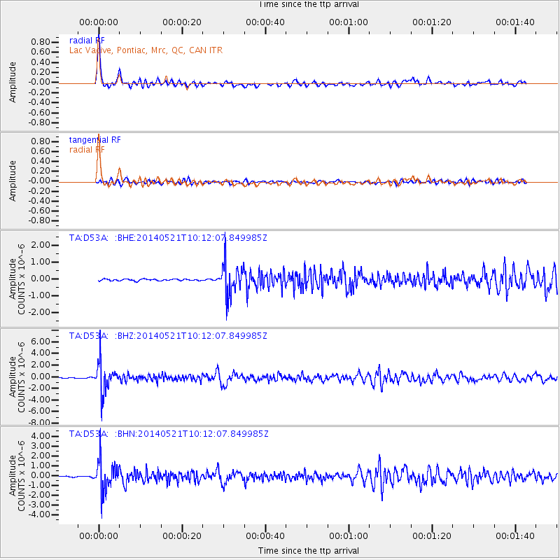
D53A Lac Vacive, Pontiac, Mrc, QC, CAN - Earthquake Result Viewer

| Earthquake location: |
Chiapas, Mexico |
| Earthquake latitude/longitude: |
17.2/-94.9 |
| Earthquake time(UTC): |
2014/05/21 (141) 10:06:14 GMT |
| Earthquake Depth: |
128 km |
| Earthquake Magnitude: |
5.6 MWP |
| Earthquake Catalog/Contributor: |
NEIC PDE/NEIC COMCAT |
|
| Network: |
TA USArray Transportable Network (new EarthScope stations) |
| Station: |
D53A Lac Vacive, Pontiac, Mrc, QC, CAN |
| Lat/Lon: |
47.08 N/77.70 W |
| Elevation: |
347 m |
|
| Distance: |
33.0 deg |
| Az: |
21.783 deg |
| Baz: |
211.267 deg |
| Ray Param: |
0.07801946 |
| Estimated Moho Depth: |
42.75 km |
| Estimated Crust Vp/Vs: |
1.74 |
| Assumed Crust Vp: |
6.622 km/s |
| Estimated Crust Vs: |
3.806 km/s |
| Estimated Crust Poisson's Ratio: |
0.25 |
|
| Radial Match: |
89.29421 % |
| Radial Bump: |
366 |
| Transverse Match: |
72.26661 % |
| Transverse Bump: |
400 |
| SOD ConfigId: |
626651 |
| Insert Time: |
2014-06-04 10:43:55.372 +0000 |
| GWidth: |
2.5 |
| Max Bumps: |
400 |
| Tol: |
0.001 |
|
Signal To Noise
| Channel | StoN | STA | LTA |
| TA:D53A: :BHZ:20140521T10:12:07.849985Z | 40.903908 | 2.544509E-6 | 6.2206986E-8 |
| TA:D53A: :BHN:20140521T10:12:07.849985Z | 22.658295 | 1.513787E-6 | 6.68094E-8 |
| TA:D53A: :BHE:20140521T10:12:07.849985Z | 19.031195 | 9.2096934E-7 | 4.8392618E-8 |
| Arrivals |
| Ps | 5.2 SECOND |
| PpPs | 16 SECOND |
| PsPs/PpSs | 21 SECOND |


