You are here: Home > Network List > TA - USArray Transportable Network (new EarthScope stations) Stations List
> Station E54A Lac Daplat, Pontiac, MRC, QC, CAN > Earthquake Result Viewer
E54A Lac Daplat, Pontiac, MRC, QC, CAN - Earthquake Result Viewer
| Earthquake location: |
Chiapas, Mexico |
| Earthquake latitude/longitude: |
17.2/-94.9 |
| Earthquake time(UTC): |
2014/05/21 (141) 10:06:14 GMT |
| Earthquake Depth: |
128 km |
| Earthquake Magnitude: |
5.6 MWP |
| Earthquake Catalog/Contributor: |
NEIC PDE/NEIC COMCAT |
|
| Network: |
TA USArray Transportable Network (new EarthScope stations) |
| Station: |
E54A Lac Daplat, Pontiac, MRC, QC, CAN |
| Lat/Lon: |
46.43 N/77.19 W |
| Elevation: |
277 m |
|
| Distance: |
32.7 deg |
| Az: |
22.965 deg |
| Baz: |
212.633 deg |
| Ray Param: |
0.07818452 |
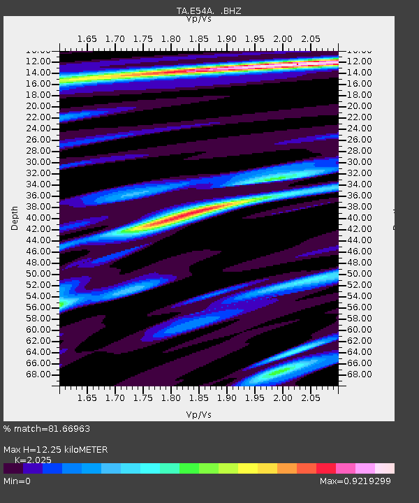
| Estimated Moho Depth: |
12.25 km |
| Estimated Crust Vp/Vs: |
2.03 |
| Assumed Crust Vp: |
6.622 km/s |
| Estimated Crust Vs: |
3.27 km/s |
| Estimated Crust Poisson's Ratio: |
0.34 |
|
| Radial Match: |
81.66963 % |
| Radial Bump: |
400 |
| Transverse Match: |
62.527256 % |
| Transverse Bump: |
400 |
| SOD ConfigId: |
626651 |
| Insert Time: |
2014-06-04 10:44:57.532 +0000 |
| GWidth: |
2.5 |
| Max Bumps: |
400 |
| Tol: |
0.001 |
|

Signal To Noise
| Channel | StoN | STA | LTA |
| TA:E54A: :BHZ:20140521T10:12:04.699015Z | 33.036045 | 3.1287761E-6 | 9.470795E-8 |
| TA:E54A: :BHN:20140521T10:12:04.699015Z | 29.306622 | 1.6364664E-6 | 5.5839475E-8 |
| TA:E54A: :BHE:20140521T10:12:04.699015Z | 16.621834 | 9.0648723E-7 | 5.453593E-8 |
| Arrivals |
| Ps | 2.0 SECOND |
| PpPs | 5.2 SECOND |
| PsPs/PpSs | 7.2 SECOND |


