You are here: Home > Network List > TA - USArray Transportable Network (new EarthScope stations) Stations List
> Station E58A La Victoria, QC, CAN > Earthquake Result Viewer
E58A La Victoria, QC, CAN - Earthquake Result Viewer
| Earthquake location: |
Chiapas, Mexico |
| Earthquake latitude/longitude: |
17.2/-94.9 |
| Earthquake time(UTC): |
2014/05/21 (141) 10:06:14 GMT |
| Earthquake Depth: |
128 km |
| Earthquake Magnitude: |
5.6 MWP |
| Earthquake Catalog/Contributor: |
NEIC PDE/NEIC COMCAT |
|
| Network: |
TA USArray Transportable Network (new EarthScope stations) |
| Station: |
E58A La Victoria, QC, CAN |
| Lat/Lon: |
46.37 N/73.28 W |
| Elevation: |
233 m |
|
| Distance: |
34.2 deg |
| Az: |
27.017 deg |
| Baz: |
218.838 deg |
| Ray Param: |
0.077447884 |
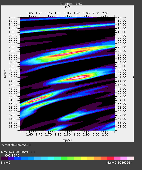
| Estimated Moho Depth: |
42.0 km |
| Estimated Crust Vp/Vs: |
1.90 |
| Assumed Crust Vp: |
6.61 km/s |
| Estimated Crust Vs: |
3.484 km/s |
| Estimated Crust Poisson's Ratio: |
0.31 |
|
| Radial Match: |
86.25408 % |
| Radial Bump: |
305 |
| Transverse Match: |
64.95008 % |
| Transverse Bump: |
400 |
| SOD ConfigId: |
626651 |
| Insert Time: |
2014-06-04 10:45:12.162 +0000 |
| GWidth: |
2.5 |
| Max Bumps: |
400 |
| Tol: |
0.001 |
|

Signal To Noise
| Channel | StoN | STA | LTA |
| TA:E58A: :BHZ:20140521T10:12:17.949991Z | 25.17166 | 2.2455274E-6 | 8.9208555E-8 |
| TA:E58A: :BHN:20140521T10:12:17.949991Z | 19.178076 | 1.3013527E-6 | 6.785627E-8 |
| TA:E58A: :BHE:20140521T10:12:17.949991Z | 15.186741 | 1.0169227E-6 | 6.696122E-8 |
| Arrivals |
| Ps | 6.2 SECOND |
| PpPs | 17 SECOND |
| PsPs/PpSs | 23 SECOND |


