You are here: Home > Network List > TA - USArray Transportable Network (new EarthScope stations) Stations List
> Station E60A Ste Agathe de Lotbiniere, QC, CAN > Earthquake Result Viewer
E60A Ste Agathe de Lotbiniere, QC, CAN - Earthquake Result Viewer
| Earthquake location: |
Chiapas, Mexico |
| Earthquake latitude/longitude: |
17.2/-94.9 |
| Earthquake time(UTC): |
2014/05/21 (141) 10:06:14 GMT |
| Earthquake Depth: |
128 km |
| Earthquake Magnitude: |
5.6 MWP |
| Earthquake Catalog/Contributor: |
NEIC PDE/NEIC COMCAT |
|
| Network: |
TA USArray Transportable Network (new EarthScope stations) |
| Station: |
E60A Ste Agathe de Lotbiniere, QC, CAN |
| Lat/Lon: |
46.37 N/71.45 W |
| Elevation: |
181 m |
|
| Distance: |
35.0 deg |
| Az: |
28.725 deg |
| Baz: |
221.565 deg |
| Ray Param: |
0.07702019 |
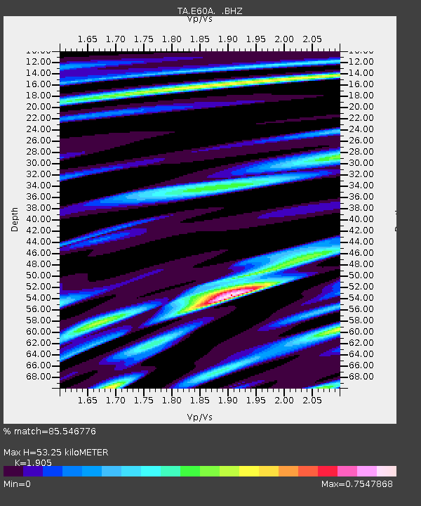
| Estimated Moho Depth: |
53.25 km |
| Estimated Crust Vp/Vs: |
1.90 |
| Assumed Crust Vp: |
6.61 km/s |
| Estimated Crust Vs: |
3.47 km/s |
| Estimated Crust Poisson's Ratio: |
0.31 |
|
| Radial Match: |
85.546776 % |
| Radial Bump: |
400 |
| Transverse Match: |
78.34187 % |
| Transverse Bump: |
400 |
| SOD ConfigId: |
626651 |
| Insert Time: |
2014-06-04 10:45:19.957 +0000 |
| GWidth: |
2.5 |
| Max Bumps: |
400 |
| Tol: |
0.001 |
|
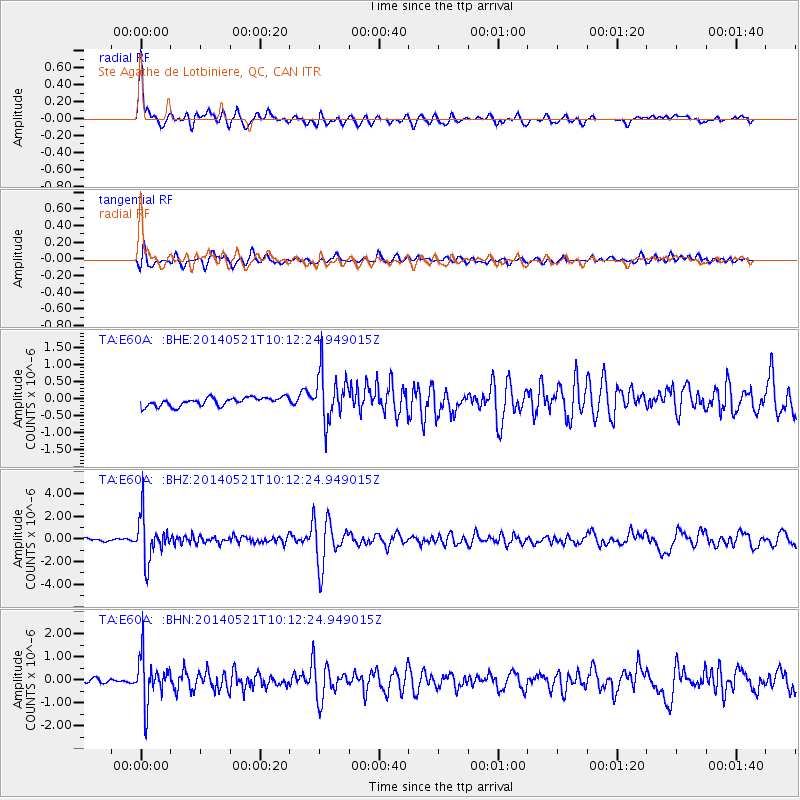
Signal To Noise
| Channel | StoN | STA | LTA |
| TA:E60A: :BHZ:20140521T10:12:24.949015Z | 13.050826 | 1.9401784E-6 | 1.4866326E-7 |
| TA:E60A: :BHN:20140521T10:12:24.949015Z | 8.711183 | 1.0090778E-6 | 1.1583706E-7 |
| TA:E60A: :BHE:20140521T10:12:24.949015Z | 5.645609 | 7.06356E-7 | 1.25116E-7 |
| Arrivals |
| Ps | 7.9 SECOND |
| PpPs | 22 SECOND |
| PsPs/PpSs | 30 SECOND |


