You are here: Home > Network List > TA - USArray Transportable Network (new EarthScope stations) Stations List
> Station F64A Sherman, ME, USA > Earthquake Result Viewer
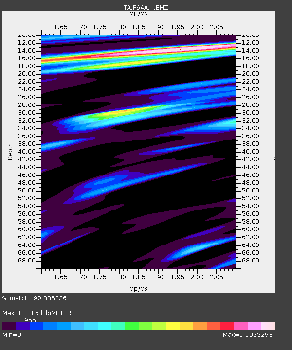
F64A Sherman, ME, USA - Earthquake Result Viewer
| Earthquake location: |
Chiapas, Mexico |
| Earthquake latitude/longitude: |
17.2/-94.9 |
| Earthquake time(UTC): |
2014/05/21 (141) 10:06:14 GMT |
| Earthquake Depth: |
128 km |
| Earthquake Magnitude: |
5.6 MWP |
| Earthquake Catalog/Contributor: |
NEIC PDE/NEIC COMCAT |
|
| Network: |
TA USArray Transportable Network (new EarthScope stations) |
| Station: |
F64A Sherman, ME, USA |
| Lat/Lon: |
45.86 N/68.35 W |
| Elevation: |
179 m |
|
| Distance: |
36.1 deg |
| Az: |
31.992 deg |
| Baz: |
226.448 deg |
| Ray Param: |
0.0764082 |
| Estimated Moho Depth: |
13.5 km |
| Estimated Crust Vp/Vs: |
1.96 |
| Assumed Crust Vp: |
6.419 km/s |
| Estimated Crust Vs: |
3.283 km/s |
| Estimated Crust Poisson's Ratio: |
0.32 |
|
| Radial Match: |
90.835236 % |
| Radial Bump: |
317 |
| Transverse Match: |
70.24077 % |
| Transverse Bump: |
400 |
| SOD ConfigId: |
626651 |
| Insert Time: |
2014-06-04 10:46:27.166 +0000 |
| GWidth: |
2.5 |
| Max Bumps: |
400 |
| Tol: |
0.001 |
|

Signal To Noise
| Channel | StoN | STA | LTA |
| TA:F64A: :BHZ:20140521T10:12:34.599985Z | 8.555826 | 1.0791836E-6 | 1.2613435E-7 |
| TA:F64A: :BHN:20140521T10:12:34.599985Z | 3.8576477 | 4.5963748E-7 | 1.19149675E-7 |
| TA:F64A: :BHE:20140521T10:12:34.599985Z | 4.091811 | 4.4603823E-7 | 1.0900753E-7 |
| Arrivals |
| Ps | 2.1 SECOND |
| PpPs | 5.8 SECOND |
| PsPs/PpSs | 8.0 SECOND |


