You are here: Home > Network List > TA - USArray Transportable Network (new EarthScope stations) Stations List
> Station G03D McMinnville, OR, USA > Earthquake Result Viewer
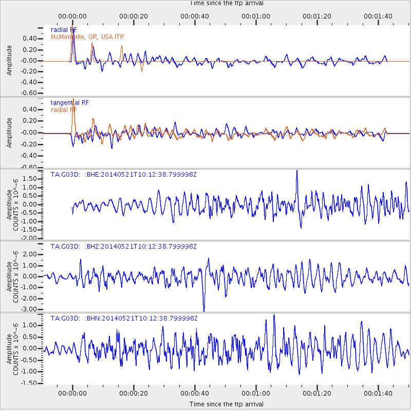
G03D McMinnville, OR, USA - Earthquake Result Viewer
*The percent match for this event was below the threshold and hence no stack was calculated.
| Earthquake location: |
Chiapas, Mexico |
| Earthquake latitude/longitude: |
17.2/-94.9 |
| Earthquake time(UTC): |
2014/05/21 (141) 10:06:14 GMT |
| Earthquake Depth: |
128 km |
| Earthquake Magnitude: |
5.6 MWP |
| Earthquake Catalog/Contributor: |
NEIC PDE/NEIC COMCAT |
|
| Network: |
TA USArray Transportable Network (new EarthScope stations) |
| Station: |
G03D McMinnville, OR, USA |
| Lat/Lon: |
45.21 N/123.26 W |
| Elevation: |
222 m |
|
| Distance: |
36.6 deg |
| Az: |
325.775 deg |
| Baz: |
130.483 deg |
| Ray Param: |
$rayparam |
*The percent match for this event was below the threshold and hence was not used in the summary stack. |
|
| Radial Match: |
70.63481 % |
| Radial Bump: |
400 |
| Transverse Match: |
74.34204 % |
| Transverse Bump: |
400 |
| SOD ConfigId: |
626651 |
| Insert Time: |
2014-06-04 10:46:29.308 +0000 |
| GWidth: |
2.5 |
| Max Bumps: |
400 |
| Tol: |
0.001 |
|
Signal To Noise
| Channel | StoN | STA | LTA |
| TA:G03D: :BHZ:20140521T10:12:38.799998Z | 2.0084577 | 5.434391E-7 | 2.7057533E-7 |
| TA:G03D: :BHN:20140521T10:12:38.799998Z | 1.8455597 | 3.245913E-7 | 1.7587688E-7 |
| TA:G03D: :BHE:20140521T10:12:38.799998Z | 2.00027 | 4.4652765E-7 | 2.232337E-7 |
| Arrivals |
| Ps | |
| PpPs | |
| PsPs/PpSs | |


